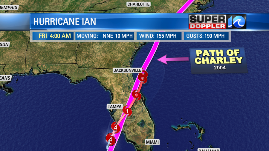
Hurricane Ian has had several changes to the forecast since yesterday. I mentioned in yesterday’s weather blog that the area of landfall would be tricky due to the angle of the storm compared to the coastline. Well, Ian has decided to take a more easterly route, and that is allowing it to hit the coast sooner and stronger.
So this morning Ian went through an eyewall replacement cycle.
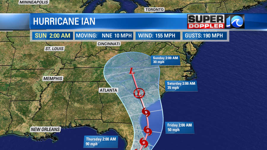
On the other side of that cycle the sustained surface winds had shot up to 155 mph. This is just shy of a category 5 hurricane. They were already getting tropical storm force winds along the coast, and those winds will ramp up through the morning.

As I mentioned already, Ian has decided to take more of an easterly track. So this meant a stronger storm. This was due to less time for the wind shear to work on it. Plus, there is less time for the cooler/drier air interact with it before landfall. This is a sharp contrast from a couple of days ago when it looked like it would make landfall closer to Cedar Key or even south of Tallahassee. The track is now very close to the track of hurricane Charley (2004).
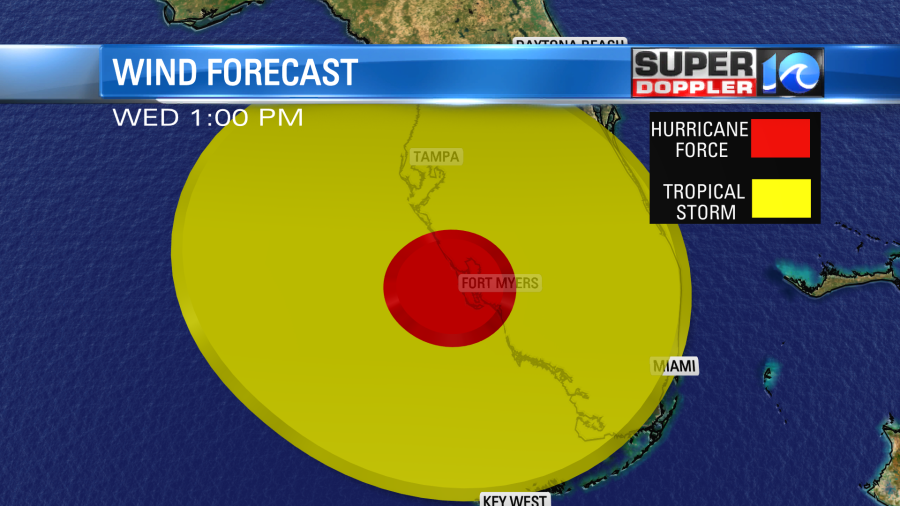
With the track trending more to the south there will be less impacts on Tampa and more impacts on Ft. Myers. Hurricane force winds will roll through there and Cape Coral between the late morning and early afternoon.
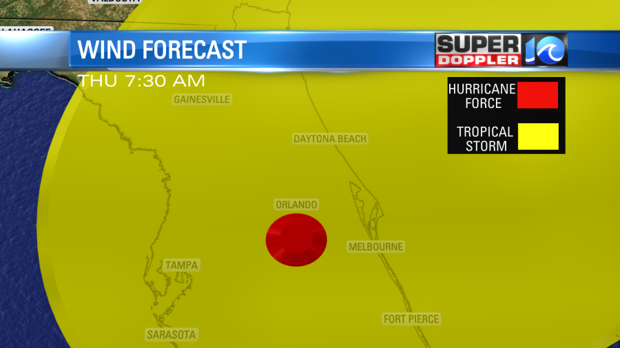
Then some of those hurricane force winds will move northeast to near Orlando later in the day.
The storm surge doesn’t look as bad now around Tampa. However, it looks worse south of Tampa.
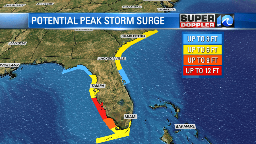
This morning at 9:00AM the National Hurricane Center put out a statement that the surge forecast had increased for a few locations. They now have 12-18ft from Englewood to Bonita Beach as well as Charlotte Harbor.
After landfall the storm should weaken fairly quickly. It is already interacting with a stalling front.
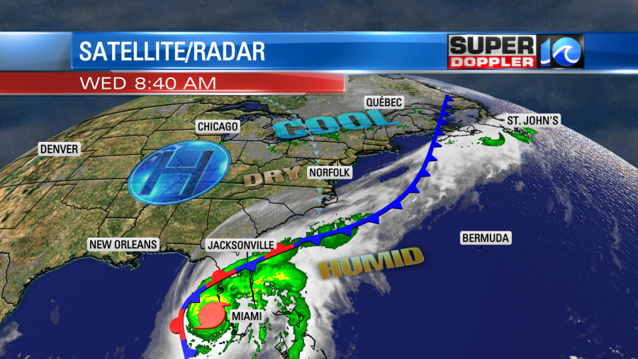
This is the same front that will bring us nice local weather today. (More on local weather in a moment).
Ian will move northeast eventually as a tropical storm. It is now forecast to move offshore for a bit. It could maintain some strength. However, the wind shear and the cooler/drier air should keep it from restrengthening. Then it will move northwest over land. It will then become a tropical depression followed by the post-tropical phase (L with no circle around it).
So all of the wind directly from Ian will stay to our southwest. However, since it is an area of low pressure to the south and high pressure is to the north there will be a strong pressure gradient. This will give us a steady and continuous breeze out of the east/northeast for several days. It won’t be a destructive wind, but it could lead to some minor tidal flooding from Sunday into early next week. Stay tuned for updates on that possibility.
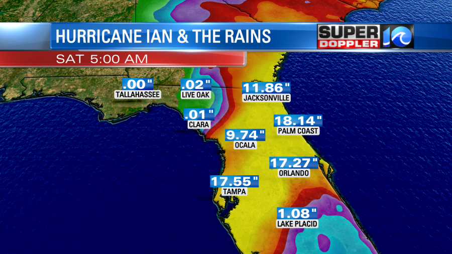
Rainfall will be huge down across Florida. Some locations could see 15-20 inches of rain. This is the rainfall forecast from the GFS Model:
That heavy rain will be around the slow moving center. However, the moisture and the rain will stretch far to the northeast of the storm. Take a look at the GFS and the European models in the short and longer term.
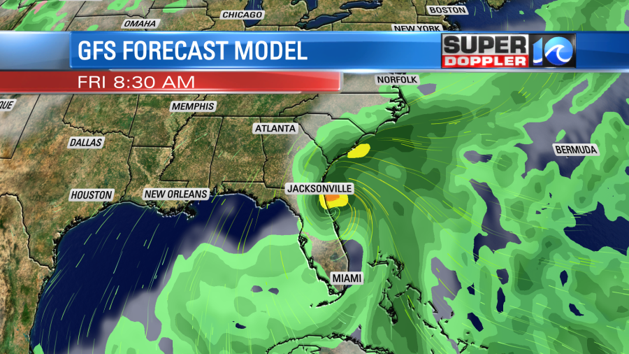
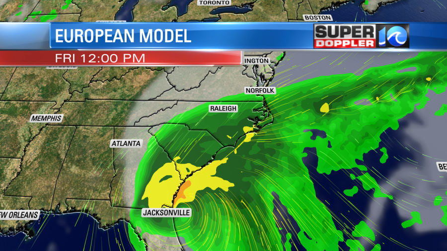
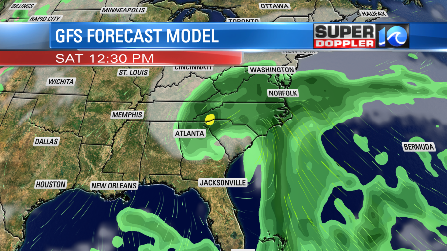
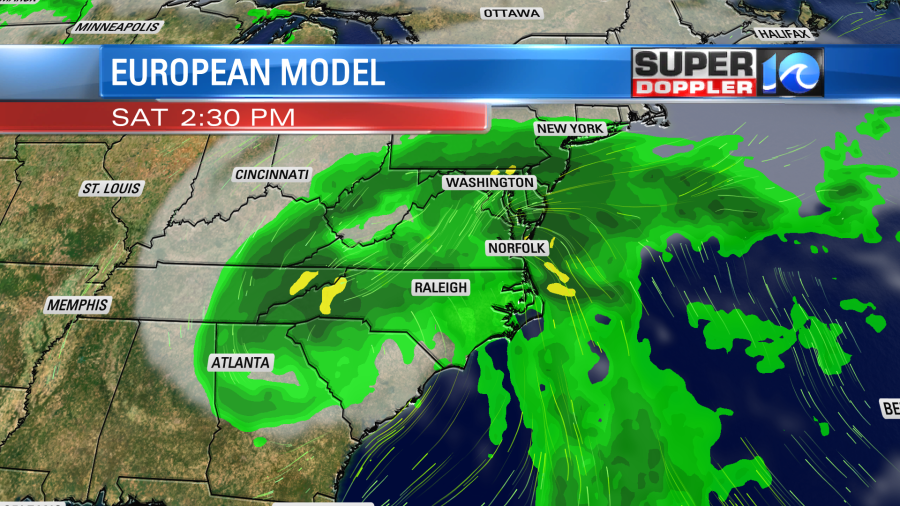
A big amount of our rain will be mainly from overunning. When you push warm/humid air northward into (and over) a cooler/drier air mass then it basically wrings out the moisture. We tend to not get thunderstorms in that case, and the rain should be steady for the bulk of the next 3 few days. However, there may be a few heavy bands. Here’s the rainfall forecast from those 2 same models:
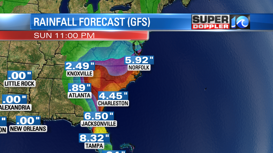
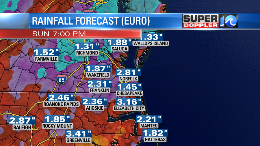
Our area is so dry right now that a lot of this rain will soak right into the ground or even runoff briefly. However, it will take a lot of rain to get flooding over the rivers and streams since they are so low. The bottom line….if the rain is spread out over the next few days, then widespread flooding shouldn’t happen. However, some localized flooding will be possible. If we do get some tidal flooding Sunday into Monday then that could lead to poor drainage. So keep that in mind. Overall, this rain will be a good thing, but it will impact outdoor events this weekend.
The local weather today looks good. We’ll be partly cloudy with more clouds over parts of North Carolina. High temps will be in the low 70s with a few upper 60s.
We’ll be dry with a light north wind. Tomorrow the wind will pick up a bit out of the northeast. Some of the gusts will be up to 20-25mph near the shore. We’ll also have increasing clouds with isolated showers. So high temps will be held down. We’ll only top off in the upper 60s. Then on Friday we’ll have a lot of rain moving up from the south.
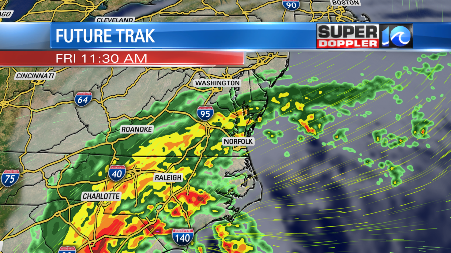
The rain will probably be on-and-off Saturday and Sunday. We’ll have more details on that over the next couple of days.
Meteorologist; Jeremy Wheeler
.


