Yesterday was as windy and cool as promised. High temps were only in the low 60s in the afternoon. Winds gusted up to 35mph in some locations. Today the wind won’t be as strong. We do still have high pressure to the north with the tropical system “Nicole” far down to our southeast.

We’ll have a northeast wind running at 10-15mph with gusts to 20mph. There will be a few gusts to 25mph this morning near the shore, but they should let up a little by the afternoon. We’ll have a mix of sun and clouds. High temps will be in the low-mid 60s.
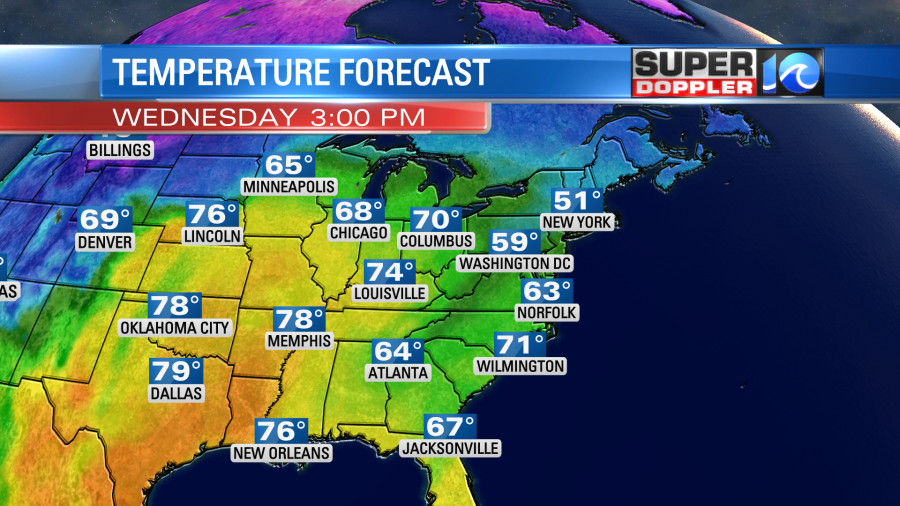
This will be just a little above where we were yesterday, but it might feel a little better with the lighter winds. Tomorrow we’ll have some nice weather. High temps will rise to the 70s with partly cloudy skies.
Winds will be light and out of the east.
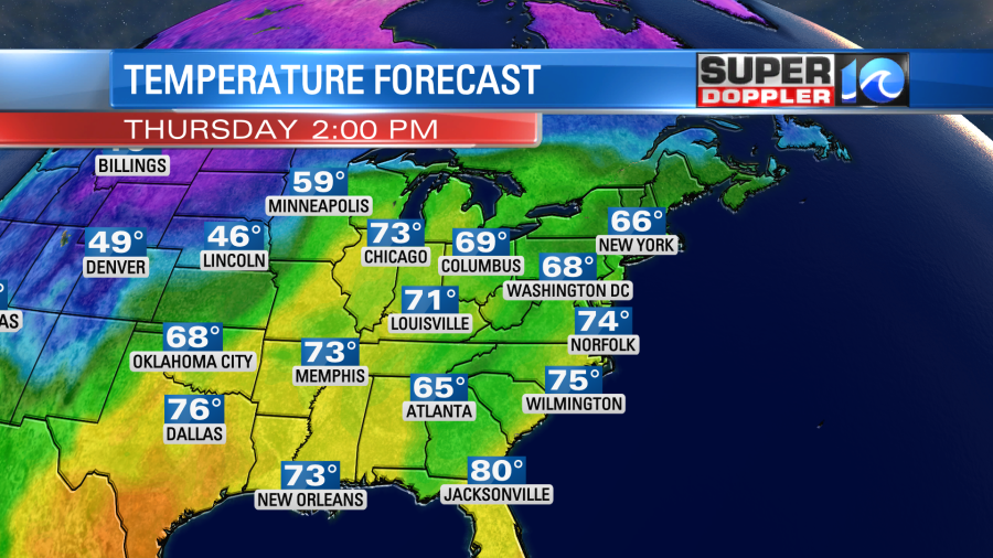
However, we will have more of a south wind develop Thursday night into Friday. So we’ll pull in a lot of warm/humid air going into the weekend. High temps will aim for the upper 70s despite lots of clouds over the area. The higher moisture will lead to some rain. I don’t think we’ll have a washout Friday. Instead I think we’ll have some scattered to occasional showers. There could also be some thunderstorms in the afternoon.
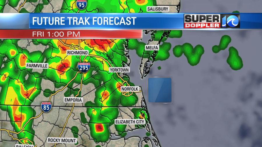
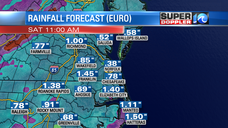
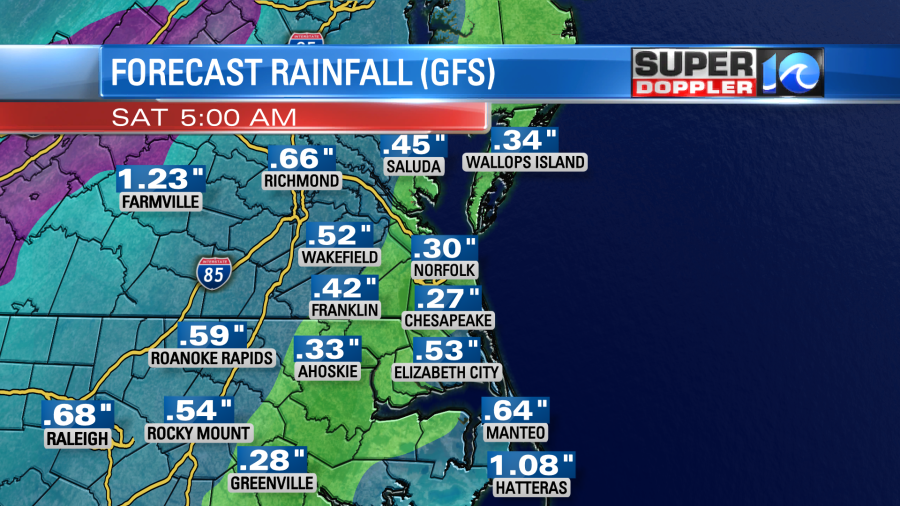
The rain will continue into Saturday morning, but it should move out by midday as a strong cold front will move offshore. The rain is going likely be from the remnants of Nicole combining with the front.
This morning Nicole was a strong tropical storm northeast of Grand Abaco Island. It was moving to the west/southwest.
The sustained winds had increased to 70mph. This brings it very close to hurricane status. It is forecast to become a hurricane soon. It will move towards coastal Florida during the day today. It is forecast to make landfall late tonight or early tomorrow morning somewhere between Fort Pierce and West Palm Beach.
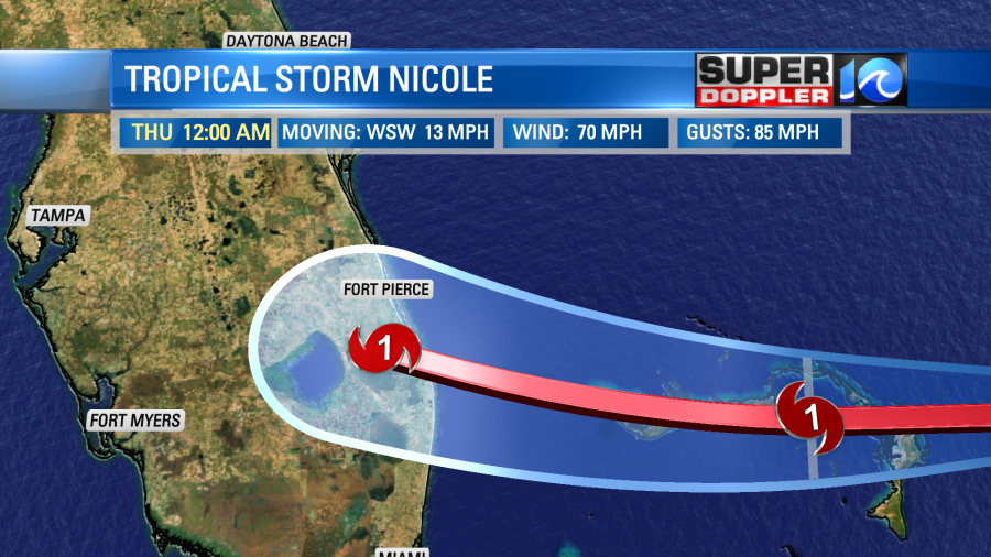
After landfall the system will move to the northwest and weaken back to a tropical storm. There’s still a chance for it to briefly move over the eastern Gulf of Mexico, but even if it does it shouldn’t restrengthen to a hurricane. The storm will turn more to the north and then northeast between Thursday and early Friday.
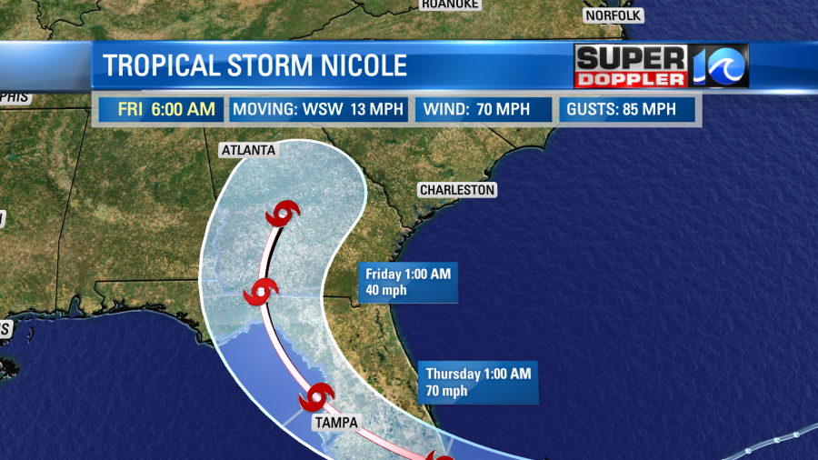
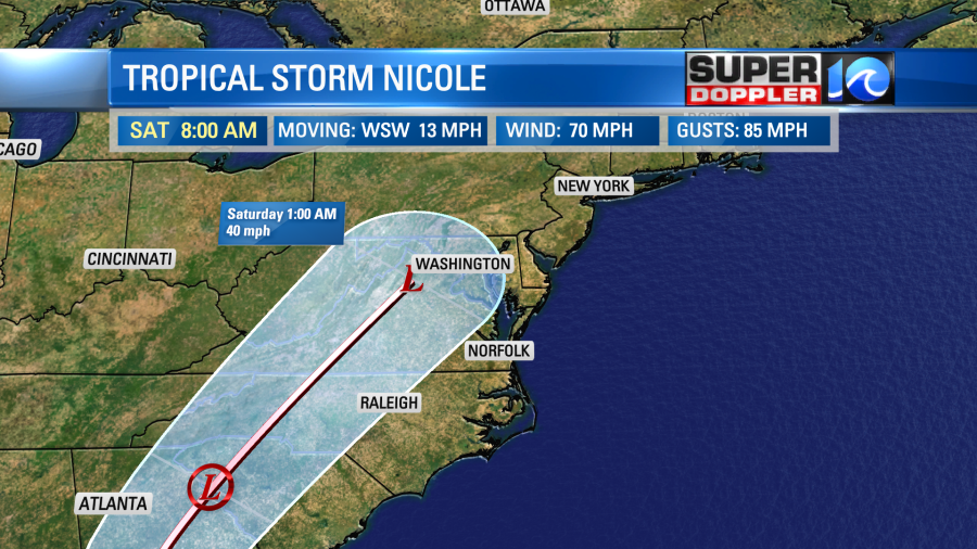
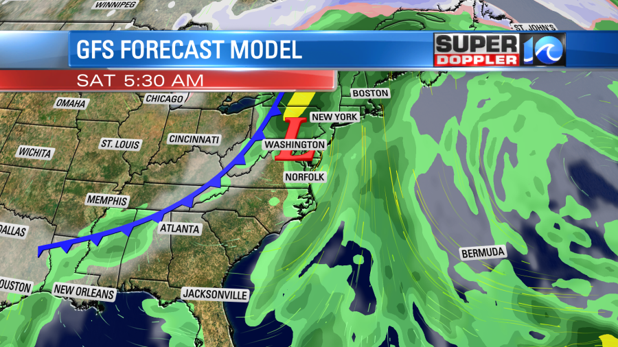
It is then expected to track northeast Friday into Saturday. As it does it will interact with a cold front. This will likely stretch-out and weaken the low. The latest track has it moving over the spine of the Appalachian mountains.
This is a big change form a couple of days ago. If you remember the forecast at that time was for Nicole to move just offshore of the southeast coast.
The models are in good agreement as to the track up through Friday morning.

After that point there is some spread in the tracks. The European and GFS models are in fairly good agreement through the next 5 days. They both have Nicole making landfall, moving into southern Georgia by Friday morning, and then weakening as it moves northeast.
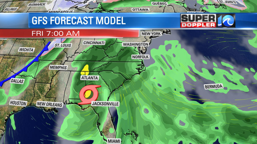
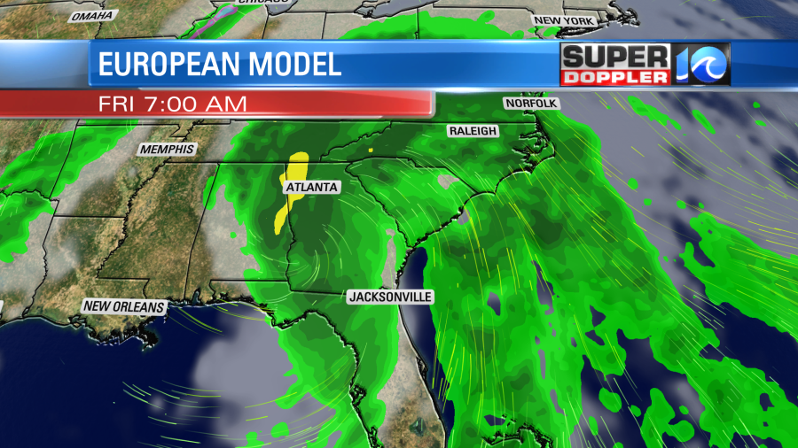
You’ll notice that the center will be over Georgia Friday morning, but the rain will stretch all the way up here into our area.
As Nicole moves northeast it will get absorbed into the strong cold front. That will stretch out the low form north to south.
If the low does weaken that much, then the wind shouldn’t be too strong from that feature. However, the south winds ahead of both features could pull up some warm, humid, and unstable air. So there will be a chance for some strong thunderstorms late Friday into Friday night. There could even be a chance for a couple of severe storms or an isolated tornado. We’ll see. The winds may also be a bit gusty behind that strong front as well. There could be some heavy downpours, but the heaviest rain overall is forecast for to our west.
After the front there will be a huge drop in temperatures. Highs on Sunday will only be in the 50s.
Keep checking back for updates on this for the next couple of days.
Meteorologist: Jeremy Wheeler


