
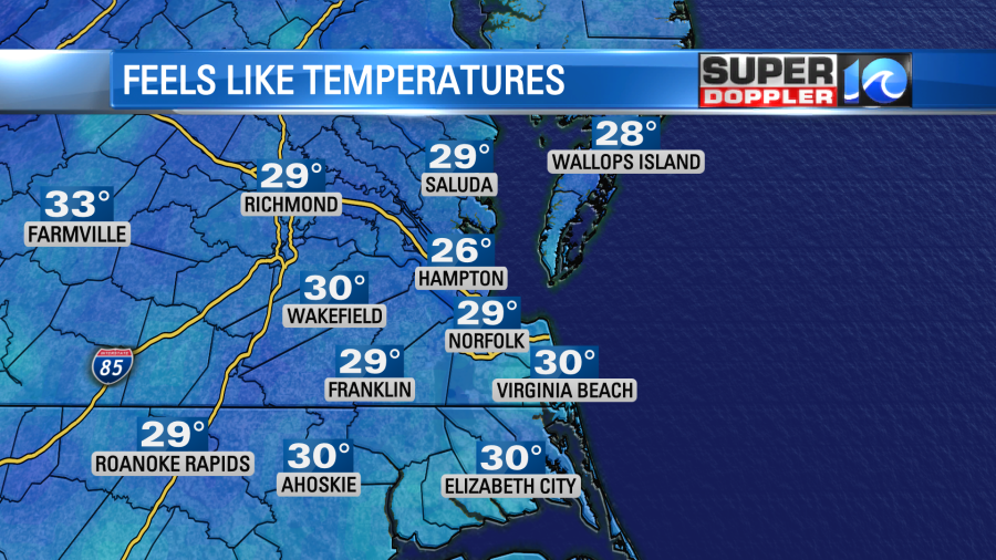
This morning there was a cold wind blowing! Temperatures were in the 30s, but wind chills were in the 20s and 30s.
Colder air is going to stick around for a while. Of course the colder air comes in during early March after a very warm January and February. Insert both eyes raised emoji here! Today we have an area of low pressure streaming offshore. Strong high pressure is building in from the west. This is creating a strong north wind between the 2 systems.
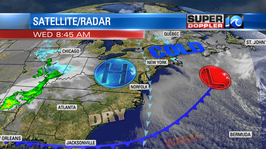
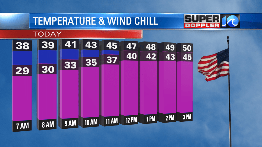
That strong wind is pushing the cold front all the way down to Florida. Temperatures will struggle to climb today. Our model has us hitting close to 50 degrees this afternoon. Keep in mind that wind chills will be in the 30s and 40s through most of the day.
There will be a little less wind inland and south. So high temps will be in the 50s there. There will be a lot of sunshine with some spotty clouds all day.
Tonight we’ll have clear skies and the winds will lighten up. They will run at 5-15mph with less wind inland. This will allow the temps to fall more than this morning. They will be in the mid-upper 30s in the metro, but they will drop to the low-mid 30s inland. Some temps could even drop to the upper 20s far inland.
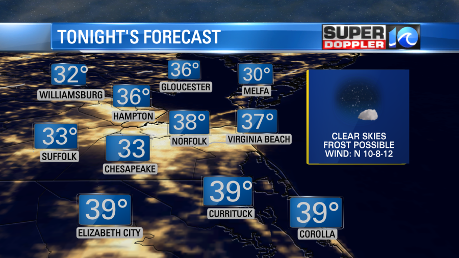
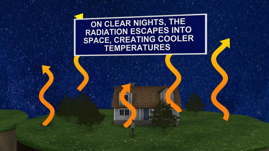
This means that there will be a higher chance for frost in the region. When there are strong winds in the overnight, it can mix the heat as it escapes the surface of the Earth. So it doesn’t flow straight up into space. However, when you have lighter winds that heat can radiate faster and stronger. So there can be more cooling in those areas.
That typically happens in more of our inland locations away from the water. So bring in the potted plants tonight. You may want to cover the blooming plants with some mulch, a tarp, or even a trash bag.
Tomorrow high pressure will be overhead. So we’ll have much less wind (North 8-12mph). We’ll still have lots of sunshine as high pressure will sit overhead. We’ll also have lots of dry air in the region. High temps will aim for near 50 degrees or the low 50s locally.
By Friday an area of low pressure will skim just to our north. Surface winds will turn out of the south for a while. This will pull up some moisture. We’ll have lots of clouds Friday with scattered rain showers moving in. The models vary in the moisture and coverage. Our model has scattered showers, but the GFS has a wider area of rain.

Either way there is a decent shot at rain from Midday Friday into Friday night. High temps will be in the 50s. Precip should move out before the cold air returns Saturday morning. However, an isolated shower may still be possible on Saturday as some moisture lingers behind the surface low. Plus, an upper level low may lag behind. Winds will be strong out of the north. So high temps will only be in mid 50s despite some clearing. I wouldn’t be surprised if there are a few bay-effect flurries Saturday evening. We’ll see. Cold air will stick around early next week. However, the long-range models are showing some even colder air by the middle of next week. Could we have high temps near 40 degrees with lows in the 20s? We’ll see. That would be really bad news for plants and fruit trees. I’ll have more on that in tomorrow’s weather blog. Until then… Stay warm!
Meteorologist: Jeremy Wheeler


