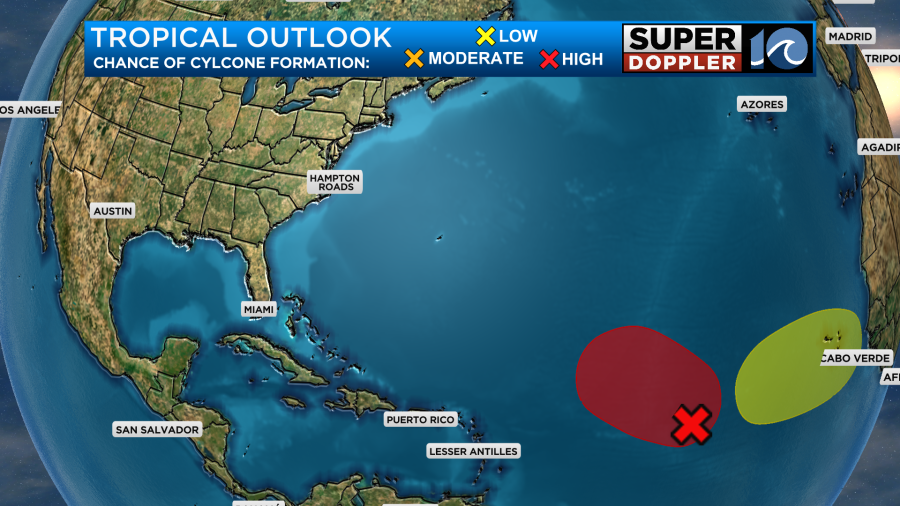
(Tropical depression 15 has formed. It is forecast to be Nigel soon. See below):
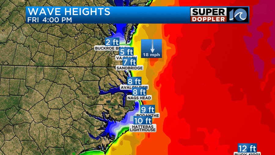
The waves are still very rough at the oceanfront today.

The waves are mostly from hurricane Lee even though it is offshore. There is probably some addition from Margot, but much less than from Lee.
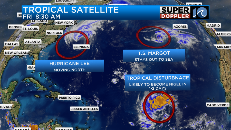
There is a potential 3rd system that is in the east/central Atlantic. It will likely become the next tropical system in the next 24-48 hours. I’ll talk more about the tropical systems in just a bit.
Update: Tropical depression 15 has formed in the central Atlantic. Here is the track:

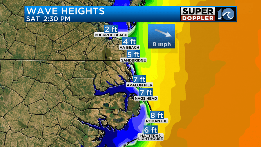
Around here we had some high waves and rough surf. The wave heights are running about 4-6ft along the Virginia Beach oceanfront. They are higher along the Outer Banks. Waves may reach up to 7-10ft down there.
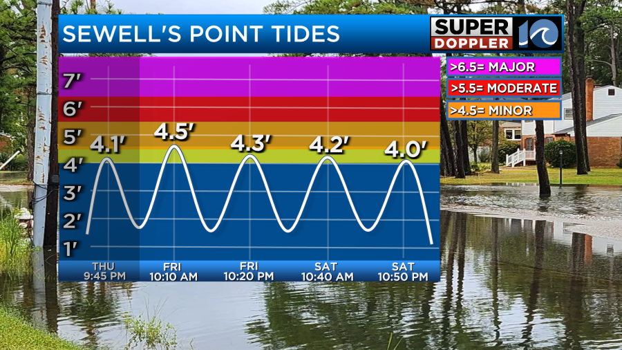
We are going to have some minimal tidal flooding as well. The highest tide will be this morning. We are forecast to get up to 4.5ft in Hampton Roads. This is the threshold for minor tidal flooding.
However, with the combination of big waves and minor tidal flooding there is going to be some ocean overwash along the Outer Banks this morning. We’ve already seen some of it happen this morning.

The overwash is likely this morning through about 9-10am. Then it is possible this evening and tomorrow morning.
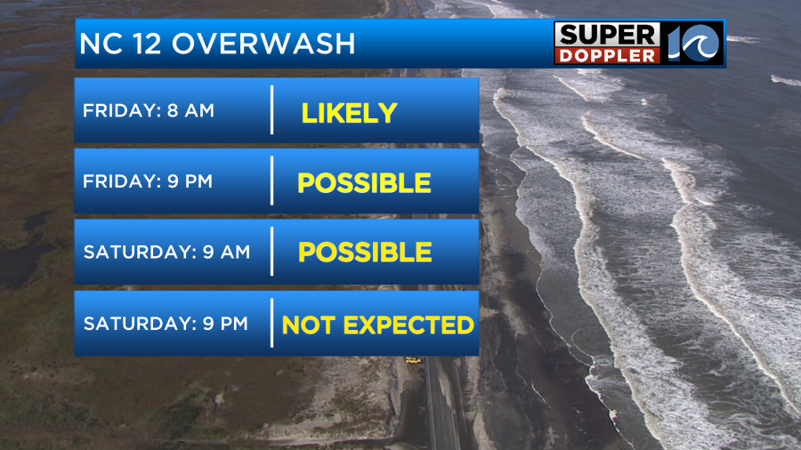
However, both the tide and waves will decrease tomorrow.
Part of the tidal flooding is from the northeast winds that we are experiencing. This is from the combination of high pressure building in from the northwest, and cold front offshore, and Lee far offshore.
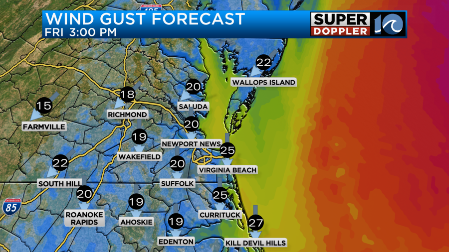
We’ll have the north/northeast breeze continue today. It will run at 10-15mph with gusts to 25mph. There may be a few gusts to 30-35mph near the oceanfront. Especially over the Outer Banks.
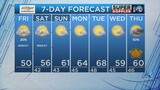
Otherwise, the weather will be great! We’ll have lots of sunshine through the day. Despite the strong sunshine, high temps will only be in the mid 70s.
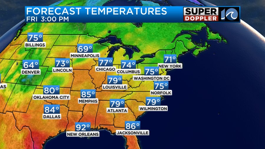
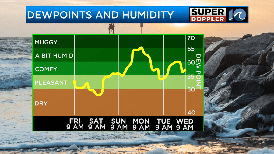
This will feel great because the air has become very dry (as forecast). Dew points are in the 50s. The dry air will continue through the weekend.
Keep in mind that it will be cool at times with the breeze. Despite the winds decreasing this evening. Some folks will want to take the jacket to the Friday night football games. Overnight the dry air and light winds will allow the temps to fall to the low 60s near the shore and in the metro. However, we’ll probably be in the 50s in a lot of inland areas. It may even drop to the upper 40s in some spots closer to I-95.
Tomorrow we’ll have some awesome weather! We’ll be mostly sunny with less wind. It will be out of the northwest at 8-12mph. After a cool start to the day we’ll warm to the low 80s in the afternoon.
Again…the dry air will be the highlight. Winds should be light on Sunday. We’ll be partly cloudy. We’ll warm up to the low-mid 80s. This will be ahead of another cold front. That front is now forecast to move through the area Sunday night into Monday morning, and that will be our best chance for rain in the next 7 days. We are needing rain again. Especially since we are going into the Fall planting season.
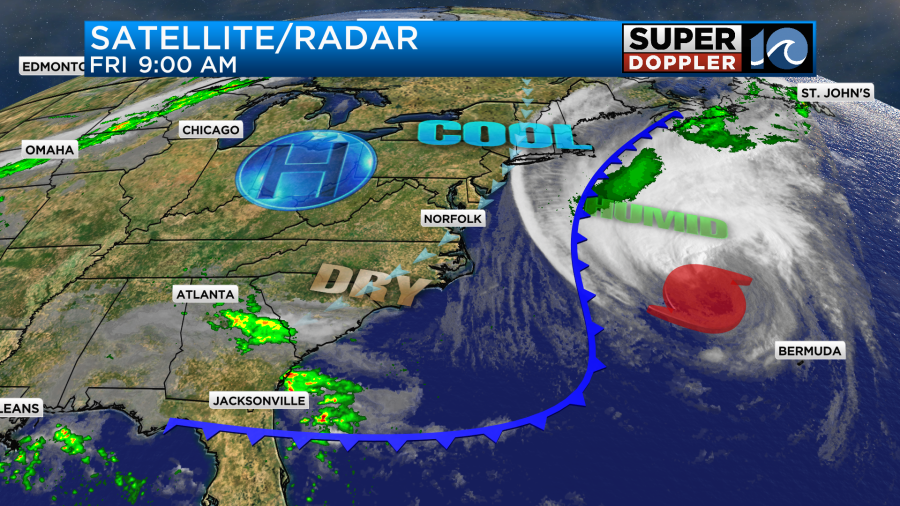
Hurricane Lee is already starting its post-tropical transition. It is opening up on the satellite, and the eye even looks exposed.
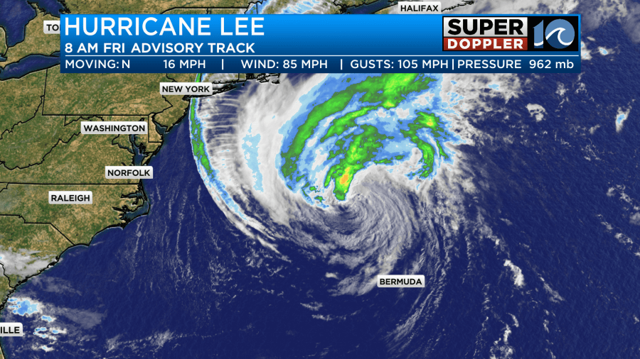
Lee will work northward, and it will become post tropical before making landfall this weekend.
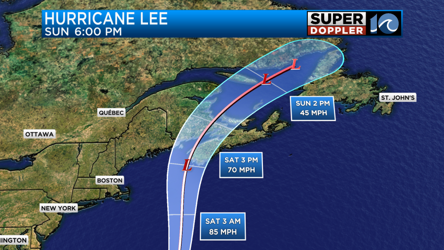
It may be a bit of a hybrid system. Either way the effects over Nova Scotia and the Gulf of Maine will be like a nor’easter. There is a pretty high confidence in Lee’s track as the models are in very good agreement through Sunday. Luckily the trend is slightly more east today. So that should mean a little less impacts on Massachusetts.
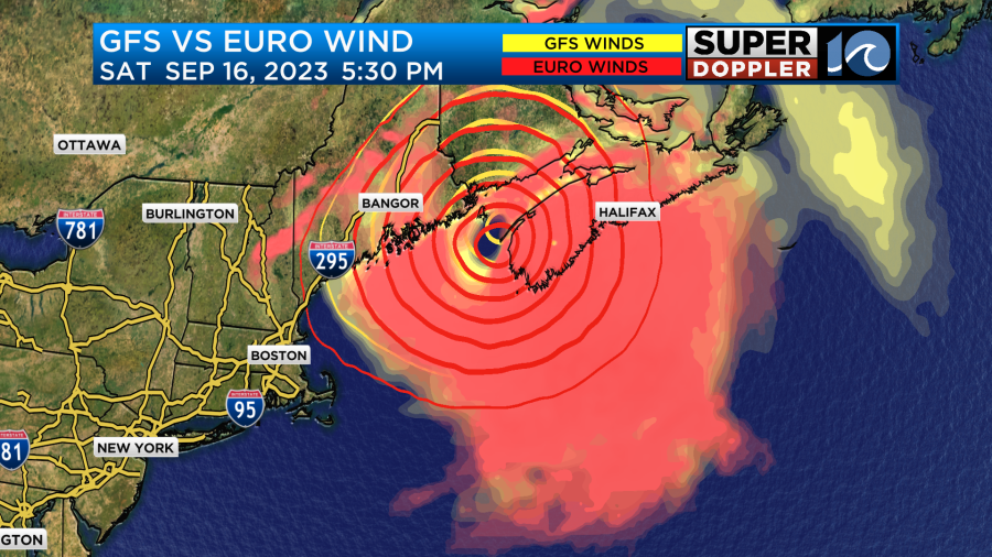
Heavy rain, strong wind gusts to hurricane force, and tidal flooding will occur Saturday into early Sunday. Then the system will weaken and move to the northeast.
Meanwhile tropical storm Margot is in the eastern Atlantic. It is meandering around, and it is forecast to do a loop and then move east in a few days.
Eventually, it will also become post-tropical.
The tropical disturbance in the central Atlantic is likely to form into Nigel in the next day or two. It will probably stay out to sea, but it’s too early to be sure.
Stay tuned for updates to the forecast.
Meteorologist: Jeremy Wheeler