
Yesterday was NICE! As expected we had lots of sunshine, dry air, and mild temps. Highs were mainly in the 70s. It was a good day to be outside. Today is also going to be a good day to be outside. We had a small pocket of thin clouds over the region this morning, but we will have a lot of sunshine through the day. A large area of high pressure is just off to our west. This will be our fair weather maker for the next 2 days.

High temps will be in the low 80s today.

It is still going to be dry. Dew points are mainly in the 50s. So it will be comfortable.
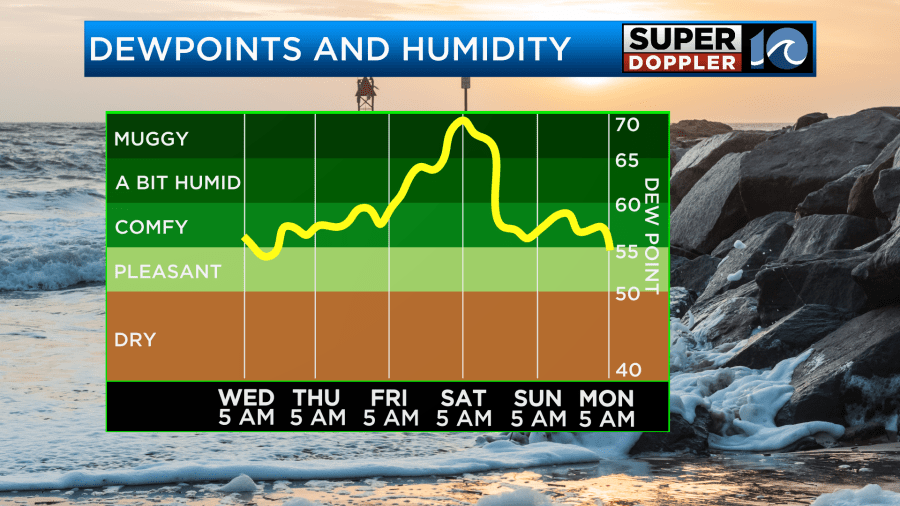
There will only be a light and variable wind. Tomorrow we’ll increase the moisture a bit. Clouds will also increase. We’ll be partly cloudy through the day with even more clouds by the evening. High temps will be in the upper 70s to near 80. It should be another nice day. However…rain and wind will increase on Friday.
The theme is set, but he finer details are still coming together. By tomorrow an area of low pressure will form and start to grow off the coast of Florida and Georgia. This low will creep north between Thursday and Friday. The low will form along a stalled out front which is pretty common for this time of year. However, this is also how tropical systems form sometimes. So there is a low chance that the low could become tropical or subtropical.

Regardless, the low will slowly lift to the north, but it will likely be offshore. There is some pretty warm water to our south. There is also a large pocket of warm/humid air down there. By Friday the low will push a lot of that moisture up into our region. The models handle the amount of moisture into our region differently, but they all agree that lots of rain will move in.
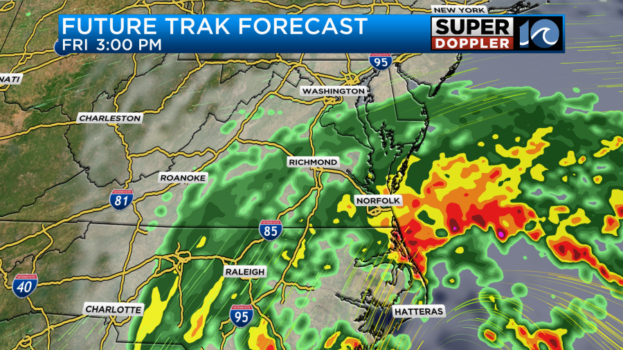

They all show that area of heavy rain nearby, but the Future Trak model is very aggressive and brings it northwest into the viewing area by Friday afternoon. This will probably be due to the interaction with a front. Winds will be breezy to windy depending on which model you believe. For now let’s just say that we could get some gusts to over 35mph. Mainly near the shore. The clouds, wind, and rain will likely keep high temps down in the low 70s. It might even be near 70 if the rain stays constant.
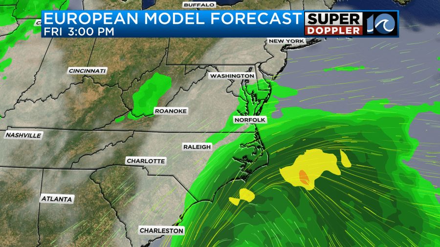
By Saturday the models bring the low up into our region. The specific strength and location differ with each model, but they are in fair agreement overall.

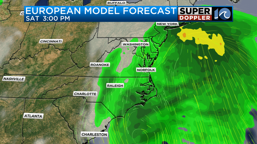
You can see that the Euro keeps the low just to our south on Saturday, and it only passes a weak low through Hatteras and then out to sea on Sunday. The Euro seems to be the calmest of the models so far. Tomorrow this will be in range of the higher-resolution models. For now the long-range models show some rain Sunday morning, but then they have drying through the day.
The latest forecasts are showing about 1-3 inches for the area with a few locations possibly getting 4-5″.
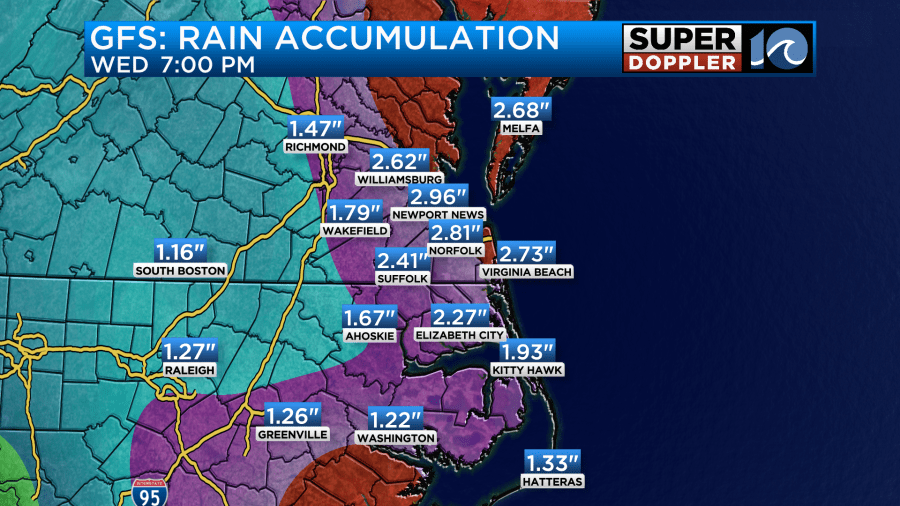
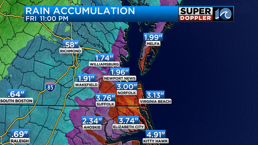
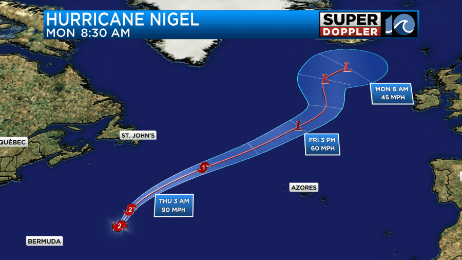
If the rain is spread out over 2-3 days, then we should be fine. However, if it comes in heavy for a time, then we could get some isolated flooding. On top of that….There may be some big waves and tidal flooding Friday into Saturday. Part of the tidal flooding will be the increasing northeast wind. However, the ocean swells will be from Nigel.
Hurricane Nigel is over the middle of the Atlantic. It was a category 2 hurricane. However, it should weaken over the next few days as it moves over cooler waters.
Due to the higher waves and water rise there may be some more beach erosion and ocean overwash this weekend. I’ll have more info on that in tomorrow’s weather blog. Check back for updates!
Meteorologist: Jeremy Wheeler


