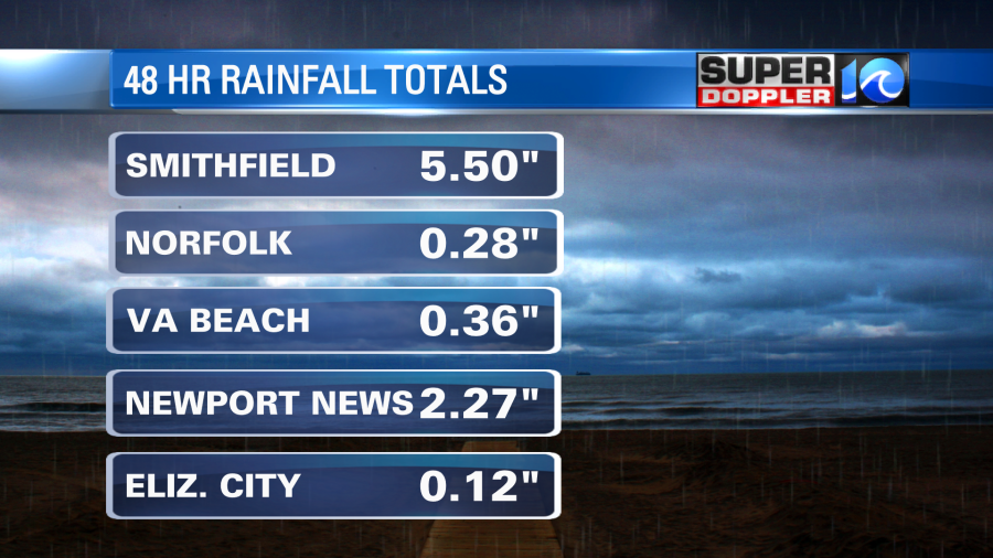
Yesterday we had clusters of heavy rain in some inland locations. A blob of heavy rain was stuck over Isle of Wight county for a while. It created some flash flooding, and there were even some flooded cars and homes. Then more flash flooding occurred north of Smithfield. Smithfield had about 5-6 inches of rain. Here are the 48 hour rain totals for some cities in the region.
Today we have a similar setup. We could see another 0.5″ to 1.5″ with some locations getting 2-3″. However, that should be isolated. There is a Flash Flood Watch in effect for areas just west of the Chesapeake Bay. This may be extended east/south later this afternoon.
We have areas of heavy rain this morning moving from south to north.
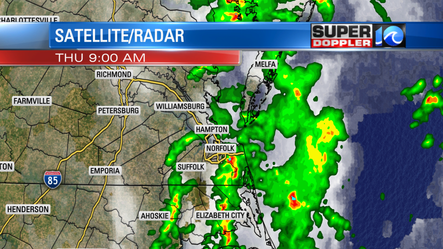
We have a similar weather pattern to yesterday. There is a lot of deep/rich moisture along the entire coast. We also have a stationary front sitting over the region.
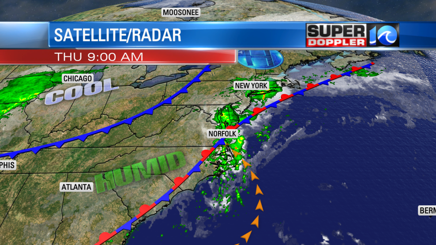
There is a weak tropical disturbance coming in off of the ocean today. It never did organize. So it will basically just enhance or potential for heavy rain today. Hopefully, there will be some decent breaks between the rain.

High temps will rise to the mid-upper 80s. This will happen because despite the clouds and rain we will have a light southeast wind along with a warm start. Remember, it is so humid that the heat index will actually feel like it’s 90 degrees. You may not realize it due to the lack of sunshine, but stay hydrated.
Tomorrow a cool front will slowly push down to the south. We’ll still be pretty warm and humid ahead of it. High temps will be in the 80s. The front will probably focus some of the rain over Hampton Roads late in the day, but scattered showers and storms could fall on and off through the day.

We’ll dry out a little this weekend behind the front, but it will stall out to our south. So there will be a few showers and storms both Saturday and Sunday. However, there should be more sunshine overall. Plus, the rain chances look lower at this time. The long-range forecast for next week looks cooler and drier for the region. Maybe some high temps in the upper 70s for a couple of days. I just want some lower humidity.
In the tropics there is a lot going on. I mentioned that the tropical disturbance that is moving onto the east coast never did form into a depression. So that will basically just bring us more rainfall. There is a tropical disturbance in the eastern Gulf of Mexico that has a low chance of formation. There is also one east of Florida that has a low chance of formation. Both of those are moving generally to the west.
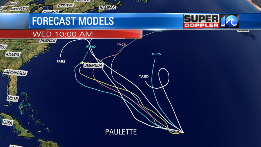
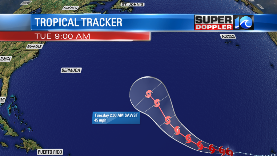
Tropical storm Paulette is expected to weaken in the short-term. Then it is expected to strengthen in a few days as it moves towards Bermuda. It could briefly become a hurricane around that time.
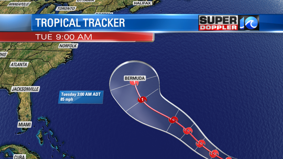
the models do keep it out to sea after that point.
Meanwhile tropical storm Rene is on a steady west/northwest track. It should turn more to the north in a few days. That would keep it out over the ocean.
It may also briefly become a hurricane, but then it would likely weaken over the cooler Atlantic waters by day 5. Though both will stay out to sea, we will likely have some higher waves along the coast from those systems. That would probably happen by the weekend.
There is another (I know) tropical disturbance coming off of Africa. That one already has a moderate to high chance of formation over the next few days as it moves west.
Meteorologist: Jeremy wheeler