Tropical storm Elsa is moving through North Carolina as of 3 p.m. (around Raleigh/Durham) and is expected head through just west of Hampton Roads this evening.
It head through our area starting around 6 p.m. (though outer bands started arriving around noon) and have impacts through about 11 p.m. before kicking out to sea early Friday morning.
Around 40 mph gusts and heavy rain are expected, and a tornado watch is in effect until 11 p.m.
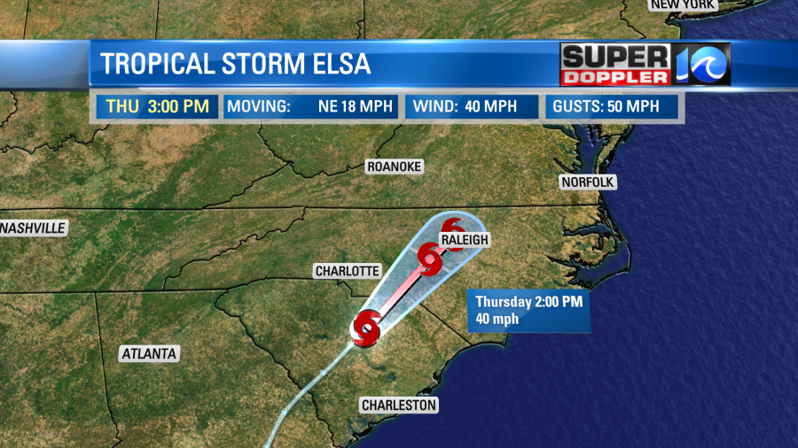
It will jet off quickly to the northeast after that point. It will probably be near Boston by tomorrow afternoon.
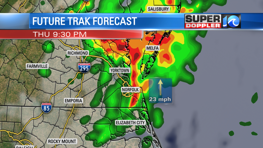
So again …That’s the center. However, the rain and wind will stretch out far from the storm. Rain bands already started to move through our area around noon, with a few storms.
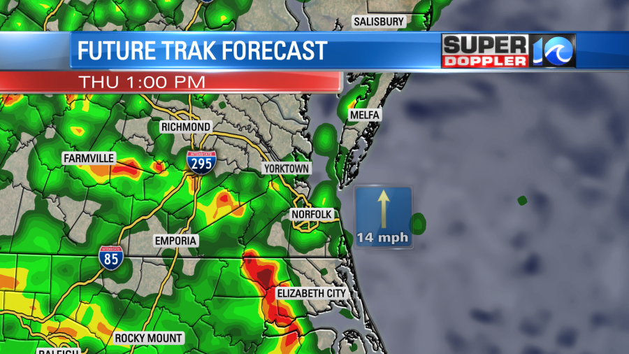
Then we’ll have a couple of rain bands between the afternoon and evening. This will impact the evening commuters. Rain may really slow down traffic with potential street flooding and reduced visibility.
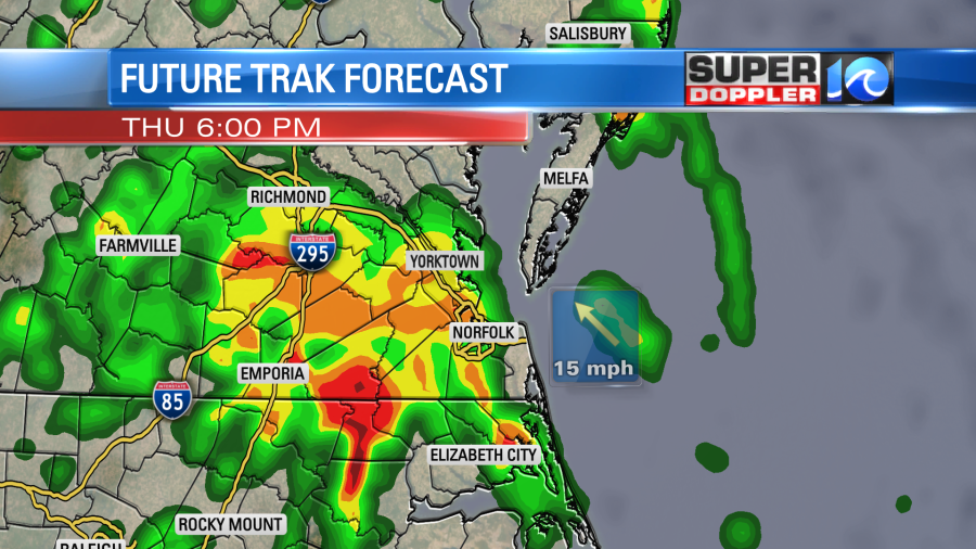
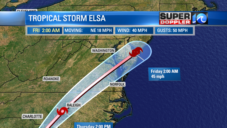
Meanwhile the center of Elsa will still be to our west during the early evening. Between about 8-11 p.m. the center will move north/northwest of Hampton Roads. There will be a big cluster of showers and storms through that time with the biggest concentration near and south of the center.
The storm and the rain will push out after about 1 a.m. Then we’ll be partly cloudy for most of Friday with a few showers and storms late in the day. Those will be ahead of a cool front and not attached to Elsa.
Rain will be heavy in the bands as well as near the center of the storm. So on its current track there is a cluster of heavier rain forecast from Hampton Roads to the northwest.
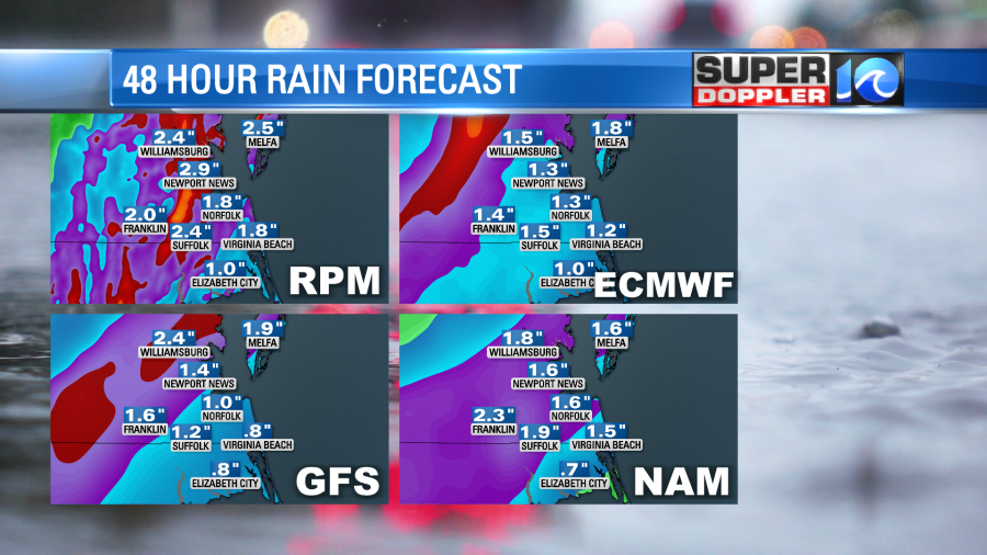
This goes along well with the area that the Flash Flood Watch covers.
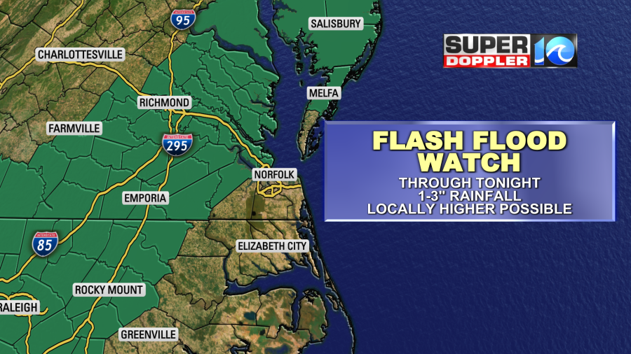
However, heavy rain will be possible east/southeast of this watch. It’s just more likely in the watch area. We could see 1-3″ of rain with locally higher amounts.
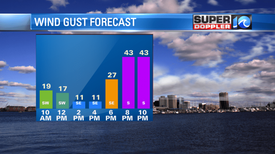
The wind won’t be too bad during the day. Winds will steadily increase out of the southwest at 10-20 mph with some gusts to 25-30 mph late in the afternoon.
There is a Tropical Storm Warning for most of the area through tonight.
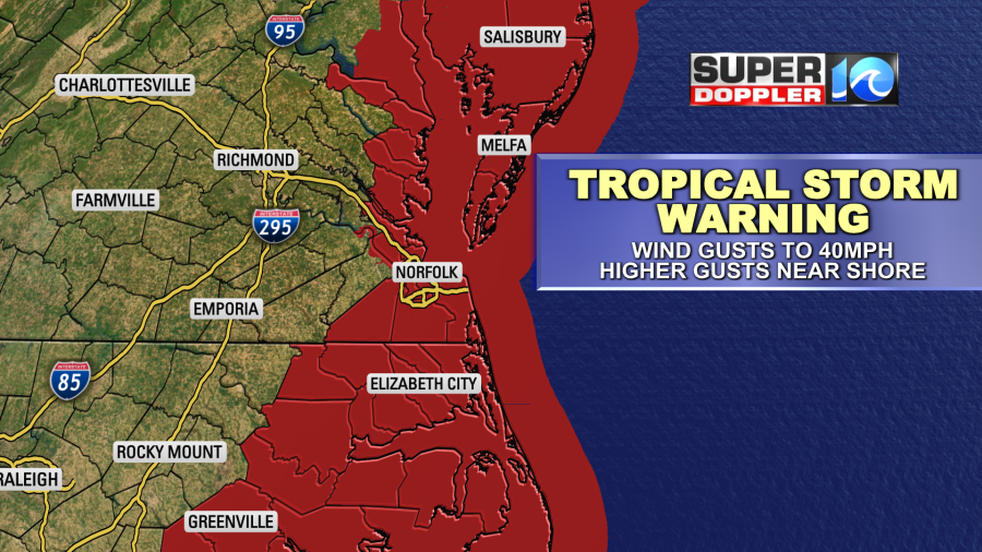
This is for wind gusts to 39mph or higher. During the evening the winds will increase over the region. They will be strongest near the shore. We could have some gusts there to 40mph or a bit higher between about 6 p.m. until 11 p.m.
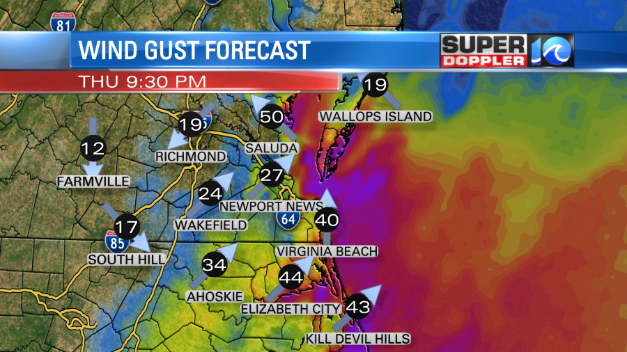
After about 8 p.m. there could be a few wind gusts up to 30-35 mph in some inland spots and the metro. The wind will die off quickly after midnight. Tomorrow we’ll have a steady breeze out of the southwest.
There is a threat for isolated (to possibly a few) tornadoes today. The highest potential for that is to the east and southeast of the center of the storm. However, I think we could see it in any of the rain bands that enter our area. For now the Storm Prediction Center has most of the area in a slight risk for severe weather (category 2 out of 5).
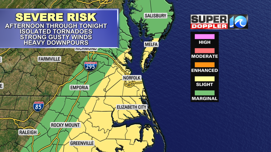
There is already a large amount of spin with the system. All it needs to do is focus down on one of the thunderstorms. There will also be a high amount of deep humidity and low clouds. So stay alert for any possible warnings that could pop off later today.
Tidal flooding shouldn’t be an issue this time around. There may be a slight water rise from the northern Albemarle Sound up into southern Virginia Beach, but it shouldn’t be bad. This is from the persistent southwest then southeast winds.
The weather tomorrow will be warm and humid with partly cloudy skies. There will be a few showers and storms late in the day. Then a cool front will move through Friday nigh into Saturday morning. This could bring a few more scattered showers or storms, but they shouldn’t last too long. We’ll be mild Saturday with highs in the 80s. We’ll be hot and humid Sunday with a few p.m. showers and storms. Overall, the weekend will be much quieter.
Stay tuned for updates through the day.
Meteorologist: Jeremy Wheeler