Yesterday was very hot and humid before a big area of thunderstorms formed. Temps were in the low-mid 90s with the heat index in the mid-upper 90s. Then the storms arrived.
These storms caused numerous reports of wind damage and high wind gusts.

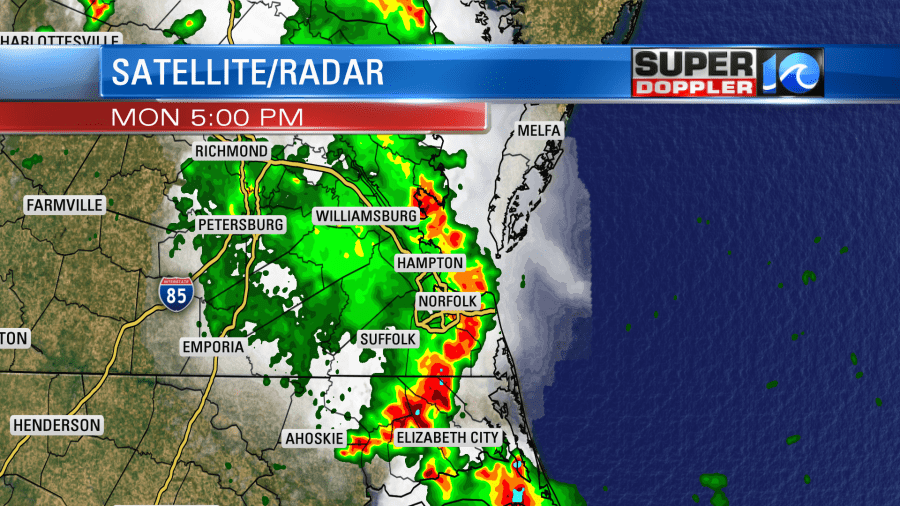
We picked up about a quarter to 3 quarters of an inch of rain with some spots getting over an inch. There was a small trough over our area, and that helped to trigger the storms. Today that feature (black broken line below) is off to our west.

High pressure is to our southeast. There is a cold front over the Midwest. We’ll be partly cloudy today with some isolated showers and storms popping up this afternoon. However, there will be a few more showers and storms this evening between about 5 and 7pm. Keep this in mind if you are heading out to vote during that time. High temps will be in the low-mid 90s today. However, it will feel like the mid-upper 90s with the heat index. There will be a bit of a breeze out of the southwest. It will run at 5-15mph.
Tomorrow we’ll have a little higher chance for scattered showers and storms in the afternoon. High temps will be slightly cooler, but not really enough to notice. They will be in the upper 80s to low 90s. Then the cold front will arrive by Thursday. We’ll have more clouds, scattered showers and storms, and high temps will be in the 80s.
We’ll start heating up again Friday into the weekend. High temps will be in the upper 80s to low 90s. Luckily the models are showing hardly any rain for the weekend. Stay tuned for updates on that.
Speaking of heat… There has been a lot of heat in other parts of the world lately. There is a slightly ahead-of-schedule heat wave over in the western and central U.S. There has been recent record heat in the northeastern U.S. and Canada. Also, there has been a long and strong heat wave over Siberia. There was a reading there recently that may be the highest recorded temperature north of the Arctic Circle.
Locally, we had a cooler than average May, and part of June was a bit cool. Now we have some seasonable heat in the area.
Finally, in the tropics..There is a subtropical depression that could become a tropical depression later today.
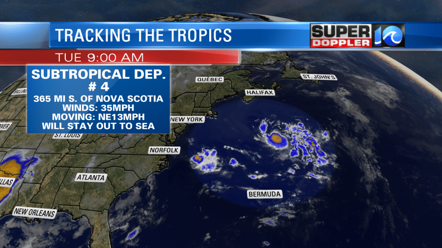
It is southeast of Nova Scotia by a few hundred miles. It will stay out to sea. However, it could bring us a few waves later this week. Stay tuned for updates.
Meteorologist: Jeremy wheeler