Well, there’s no doubt that the region had a lot of snow falling out of the sky last night. However, a lot of that snow melted in the metro area. Luckily that helped out the roads and sidewalks as many of them had completely melted before dawn.
As expected there was an area of low pressure that formed well to our south, and a lot of moisture was pushed north of that system towards Hampton Roads. Meanwhile a large/strong area of high pressure was spreading out over most of the U.S. Northerly winds on the eastern side pushed cold air south to meet the moisture. The effect was a wintry mix that changed over to a band of snow last night.
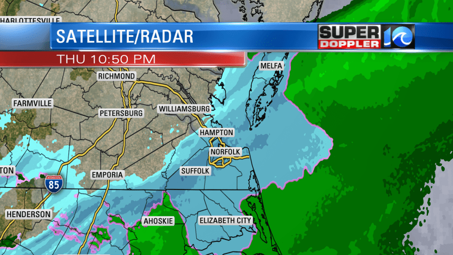
Now the surface low has moved farther offshore. The high is building in slowly from the northwest.

Strong northerly winds have increased even more in our viewing area. Gusts have been above 30mph in some places. Temperatures have dropped to the upper 20s to low 30s. So wind chills are in the teens and 20s as I write this. We’ll stay cold and dry today. High temps will only be in the upper 30s. Wind chills will be in the 20s even during the afternoon.
As I mentioned there was a lot of melting last night. Some of that melt may refreeze for a while this morning. So there will be patches of snow, ice, and black ice for a while. Be careful as you go out and about.
So how did we do on the forecast? Some places were predicted better than others. Here was my last forecast map from yesterday before I left for the day:
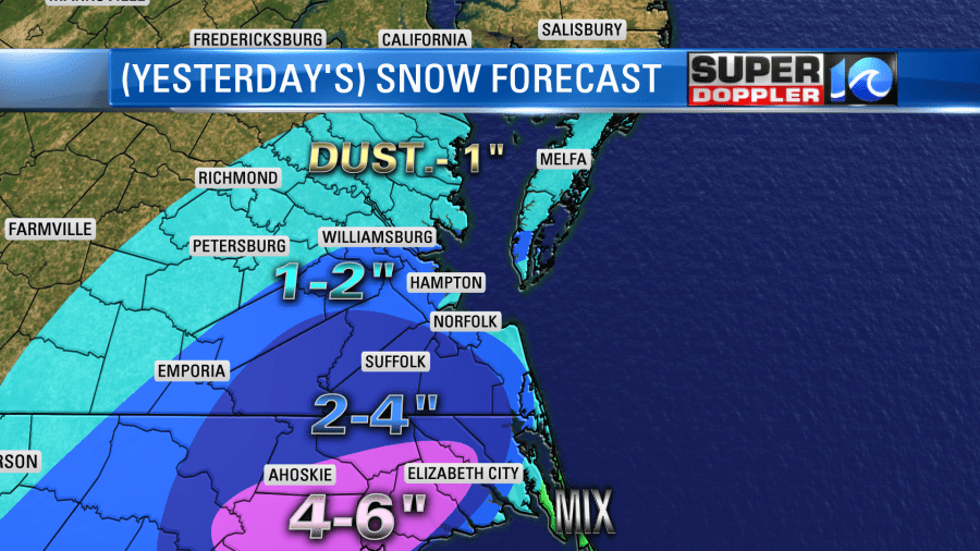
I had a good amount in-between Chesapeake, Suffolk, and Franklin down to Bertie and Gates counties. I had 1-2 for a lot of the Peninsula. However, I pulled the 1-2 inches a little more south yesterday before midday out of the Middle Peninsula and Eastern Shore. That was a mistake. Here are some of the totals. Many of them were from Facebook:
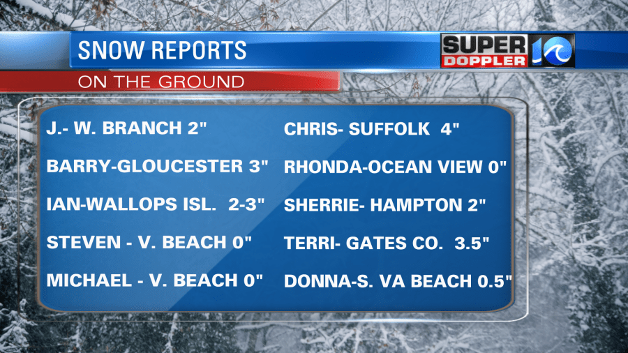
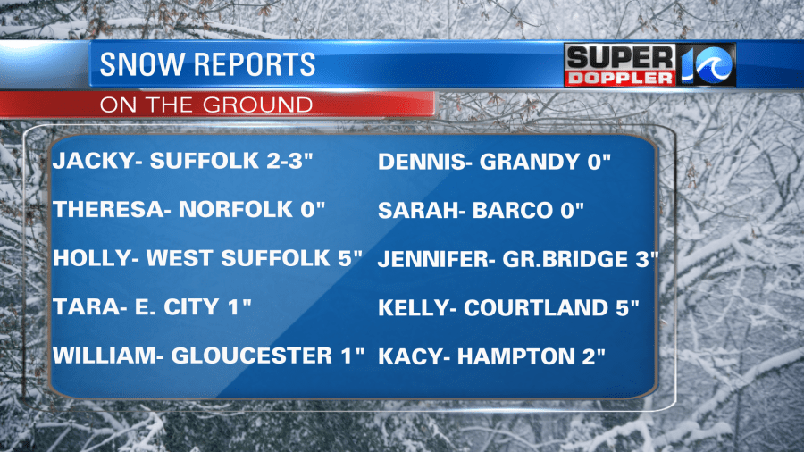
In the end, there was about 1-2″ on the ground on the Eastern Shore and Middle Peninsula. A couple of spots hit 3″. It was about 1-2″ over the Peninsula. So that was good. We had a pretty solid 2-4 inches for Chesapeake west to Franklin. However, some of that region had 4-5″. It was about 3-4″ from Hertford county N.C. to Perquimans county. However, it was a sharp cutoff east of Elizabeth City. It almost all melted from Currituck County to the Outer Banks, according to the reports I saw. We did call for that to happen as many models did as well. One place where we did better than other outlets was Virginia Beach and Norfolk. Take a look at my closer map:
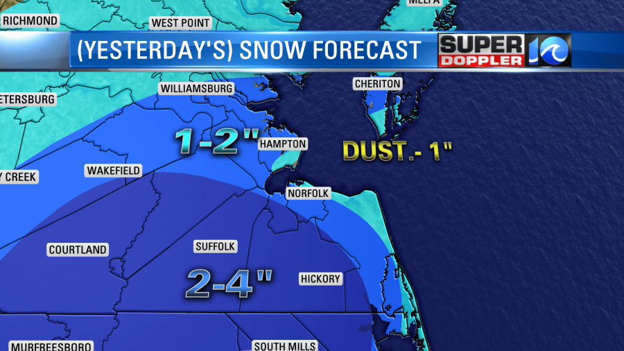
Over the last couple of days I talked about the warm ground temps and the seasonably mild water temperatures on the Bay and Ocean. The winds were forecast to be strong out of the north, and that was expected to be a factor. So I had lesser amounts over Virginia Beach and part of Norfolk (I tried to edge it into northern Portsmouth, but it was too hard). Anyway, that warming/melting came to fruition, and the effect was even stronger than we thought it would be. So a lot of Virginia Beach and Norfolk had nothing to a dusting. There was about a half an inch away from the water. Some other forecasters did not take this into account. So their 3, 5, 7 inches did not pan out. There was a little in downtown Portsmouth (about a dusting to a half an inch), but a little more in western Portsmouth.
If there was no melting, then I think a lot of the region would have had about 5-8″ of snow. However, melting was a factor all over. I believe ground temps were in the 40s before this event. Air temps stayed above freezing for a while last night, but they were in the low-mid 30s.
So I’m not patting myself on the back too much, but hopefully people give me credit for sticking to my guns on the lesser amounts in the metro. And let me tell you….There was some big pressure to go higher.
After today we’ll warm things up over the weekend. High temps will be in the low 50s on Saturday with fair skies. We’ll be in the mid 50s on Sunday. We’ll be dry and mild on Monday, but some isolated showers may move in late in the day. Then we’ll have some rain with high temps in the 60s Tuesday and Wednesday.
Thanks for all of the reports from folks this morning. It really helped to tell the story. Enjoy the snow for those that got it. If it melted in your neighborhood, then take a drive west. You’ll see it.
Meteorologist: Jeremy Wheeler


