
This morning started off nice. We have some high/thin clouds in the region. Temps were mainly in the 50s. It was dry and cool with only a light breeze for a change.
Today will be another nice day. We have strong high pressure edging into our region.

We’ll have fair skies this afternoon with high temps rising into the upper 70s to near 80 degrees. Winds will be light and out of the northwest. It is still dry at the surface. Dew points are in the low 50s, and that is great! We’ll stay dry tomorrow. However, some deeper moisture down to our southwest around the remnants of Beta (more on that in a moment) will keep pushing up into the region. It will bring us partly to mostly cloudy skies Thursday, but no rain The surface wind will be light and out of the southwest. So high temps will be near 80. As we go into Friday and the weekend the humidity will ramp up.
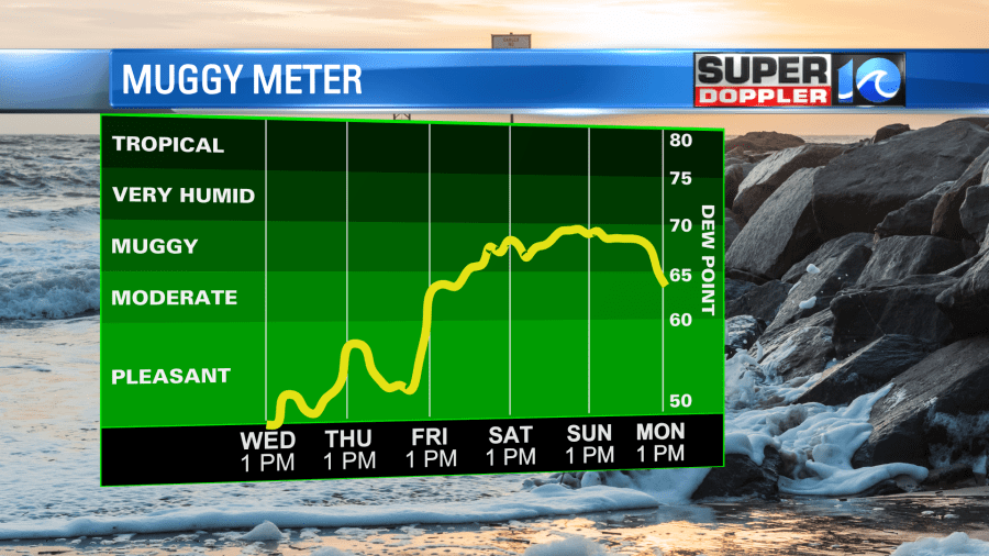
Dew points will climb into the 60s. The models disagree on how much moisture reaches our area. The European model has a lot of rain basically all day Friday through about midday Saturday. However, the GFS and NAM models are a bit more tempered. They show scattered showers late Friday into Saturday morning with less rain Saturday afternoon into Sunday.

I wouldn’t mind a little rain again, but we really don’t need a big long-term rainfall right now. So hopefully the Euro is wrong.
We should have drier weather on Sunday. Then more rain early next week. High temps will be in the low-mid 80s over the weekend. Folks that love Fall weather had a taste over the last 3 or 4 days. However, I hate to say that it was just a tease for now.
So what about the tropics? Well….There were 3 tropical systems in the Atlantic yesterday. Today they have all become post-tropical.

Having said that…Teddy is still causing problems up in Nova Scotia, Canada. They are getting pounded with strong winds and heavy rain. It is basically a strong nor’easter up there right now with tropical storm force winds.
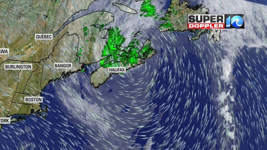
The waves are big up there. They are up to 20ft. There’s talk that a few of them could reach 30ft near the shore.

It will move generally north over the next couple days, and will eventually weaken over the cooler water.
Beta is a rainmaker now.

There are a few heavy showers still near the center, but rain is extending well northeast of the low. Again, some of that moisture will push up into our region Friday and Saturday, but we’ll see how far north the deep moisture gets.
Stay tuned for updates!
Meteorologist: Jeremy Wheeler