Update: The moisture increasing tonight will keep temperatures above freezing into Friday morning, so we anticipate some chilly rain showers for the majority of the region. The rain/snow line will be close by, so a brief wintry mix is possible for some of us.
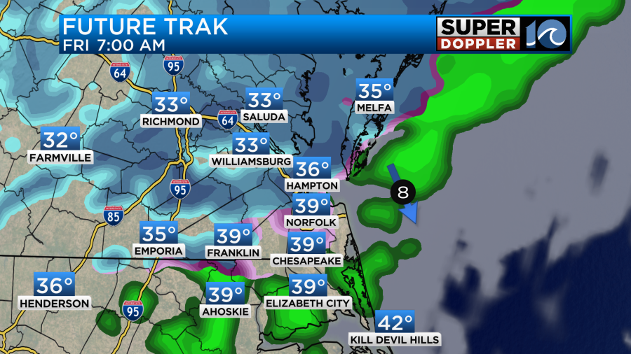
Expect increasing clouds tonight with temperatures holding in the 30s to near 40 degrees — too warm for snow by the time the precipitation begins early Friday morning. Expect chilly rain showers before sunrise Friday, taking us through the mid/late morning hours. The rain/snow line should set up as far south as Williamsburg, so locations north towards Richmond and the Northern Neck have a better chance to see some brief snowfall.
We do not expect any major accumulations or impacts other than some slick roadways during the morning commute.
There actually looks to be a better chance of seeing a brief passing snow shower or some snow flurries on Friday evening and Saturday morning as the cold arctic air comes crashing in.
There will be enough of a breeze to make Saturday feel like it’s 20 degrees almost all day, which brings us into an even colder morning Sunday, when wind chills should be around 10 degrees. Yikes! Sunshine should take over Saturday afternoon and guide us through Sunday with warmer air slowly moving in next week.
-Steve
______________________________________________________________________________________________________
Yesterday was as cold as predicted! High temps only made it into the mid 30s for many.
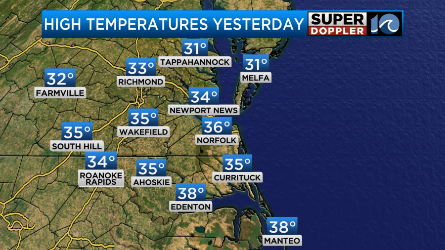
Wind chills were in the 20s in the afternoon. I put on a lot of warm gear to walk the dog around midday. It was still pretty cold. (My dog loves the cold).
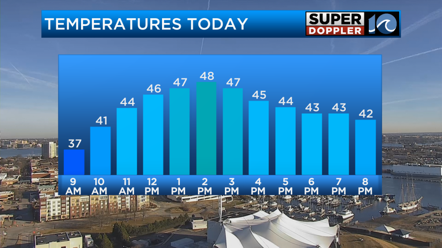
Today won’t be as frigid. We’ll have enough sunshine to warm temperatures up to the upper 40s later this afternoon.
We’ll have a light southwest wind on the north side of a big area of high pressure.
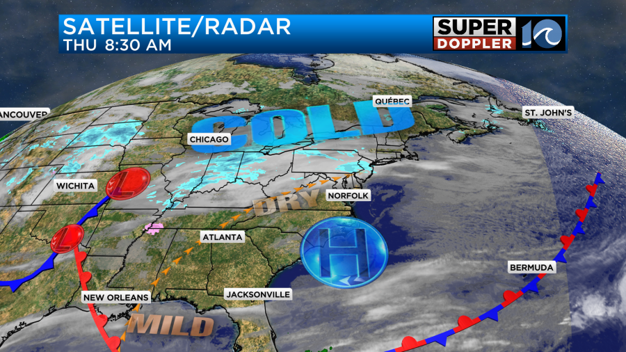
We are still very dry at the surface. However, moisture will increase in the mid-upper levels through the day. This will let the clouds increase through the day.
By tomorrow morning one area of low pressure will be moving in from the west. There will be a warm front and another weak area of low pressure offshore.
The moisture will increase by tomorrow morning, but I think we’ll still be a little dry at the surface. I also think the forecast models are handling the moisture differently. So our Future Trak model has the most moisture, and it is the coldest. It has a wintry mix in Hampton Roads tomorrow morning. It also has a little light snow just north/northwest of the metro. Even as far south as Newport News. Hampton and Norfolk are a mix.
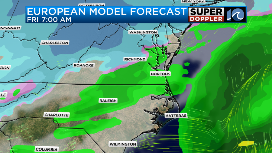
This is in big contrast to the NAM, hi-res NAM, and the Euro models which have mainly cold rain showers for our area with the rain/snow line up between Williamsburg and Richmond.
I do favor the colder temperatures, but I also think the dry air will cause some virga initially. Remember, that is precip that falls but dries up before it hits the ground. So it may look impressive on the radar at first, but it may take a little more time in the morning to really moisture up. Through the day it looks like the precip becomes very scattered. We’ll also warm up to the upper 30s to low 40s by midday.
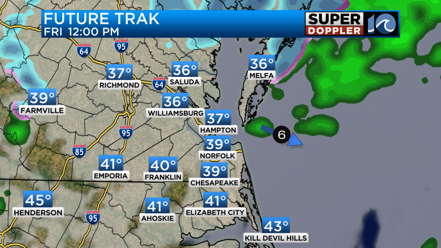
We’ll warm to the mid 40s by the afternoon (probably). Some of the raw numbers from the NAM and GFS models suggest we’ll get to 50 degrees. I don’t see that happening. Our Future trak model has low 40s with upper 30s and low 40s north of the metro.
The precip looks like it will mainly be scattered (cold) rain showers during that time.
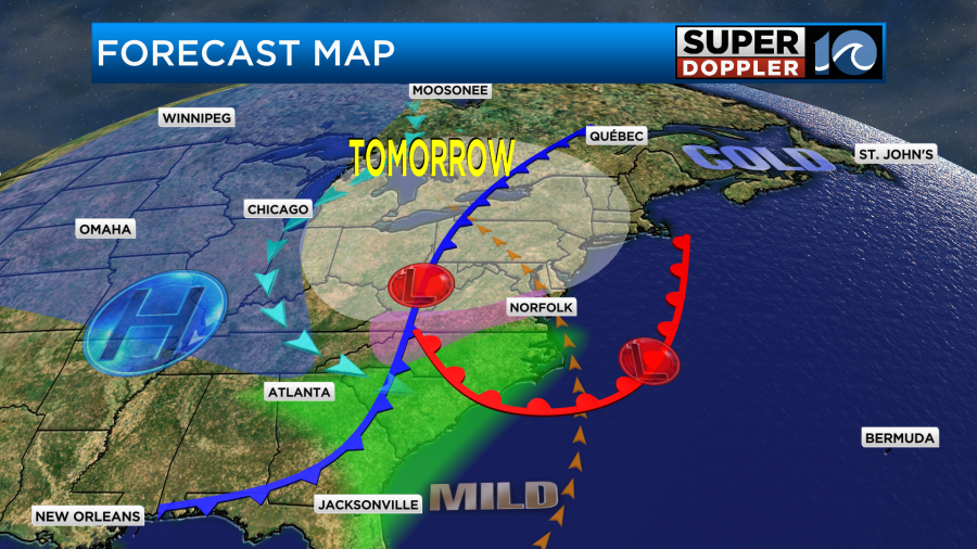
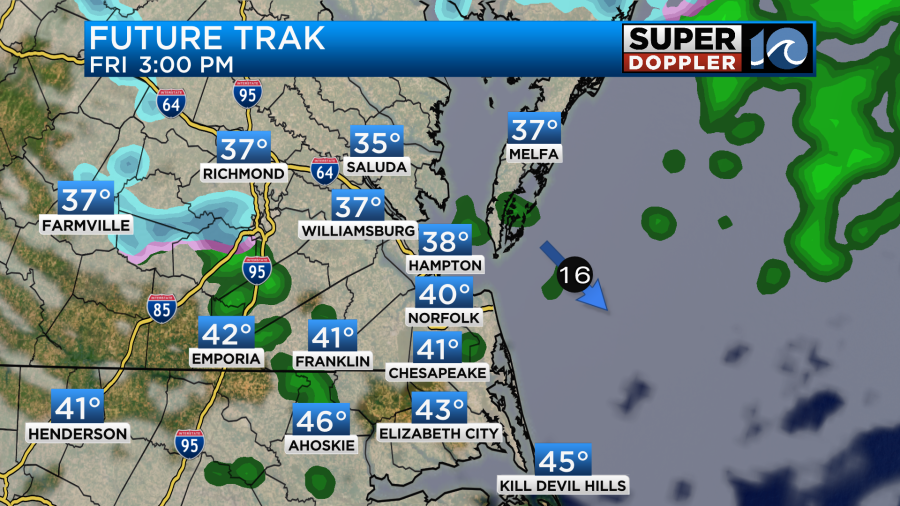
During the evening our temps will start dropping again as a cold front sinks to the south. The low should start moving away from our area, but there may be a few lingering spots of wintry mix.
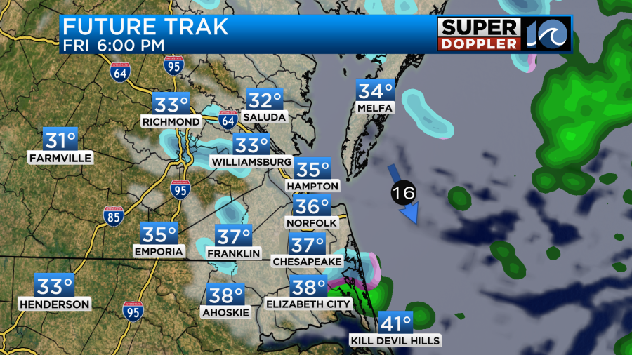
Notice that temps will still be above freezing at the time. Therefore, most of that mix should melt. Then it will all move out by the later evening as colder air rushes back in.
As far as snowfall amounts…It’s tricky. Again…our model is one of the coldest and snowiest. It even has some very light snow in the metro.

Keep in mind that most of what falls in the metro will likely melt. Surface temps will be above freezing through the day. Even in the morning. However, north and northwest of the metro temps may be cold enough for the snow to stick on some grassy areas. The highest potential for that is between Williamsburg and Richmond. So the higher amounts (around an inch) are possible there. The tricky parts comes from the other models. Many of them have hardly anything for the whole region. The GFS is a bit of a blend.
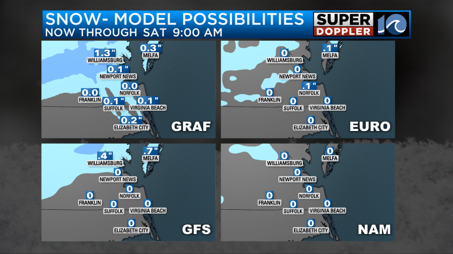
Even the hi-res NAM and the forecast from the National Weather Service show barely anything for snowfall totals.
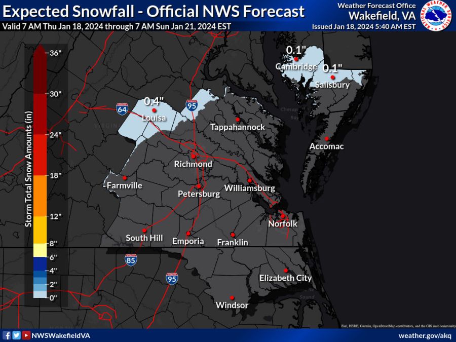
It’s hard to say why there is such a big difference between the models. I know they are handling the temps and moisture differently, but this is a pretty big split for the rain/snow line. The bottom line is that we tend to favor a melting mix in Hampton Roads. No model shows any big snow anywhere in the region. Also, even though some models show light accumulations to the north & northwest. A lot of those light amounts will likely melt or only stick to grassy areas. So I do think there will be a scattered mix tomorrow morning, but probably less than Future Trak shows. Most of the day there shouldn’t be a problem, but if a mix forms in the morning then it could cause some slow downs and slick spots during the morning commute.
After the Friday forecast things get cold and dry again. High temps will only be in the 30s over the weekend. Saturday may be colder than yesterday!
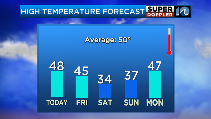
The good news is that warmer air is right around the corner. There will be a dramatic warm up next week across the country.
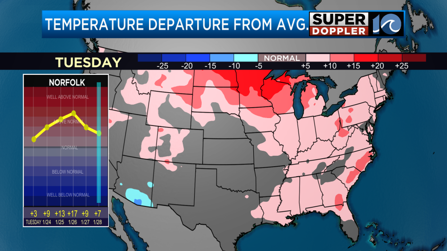
Locally we’ll probably get back to the 50s by next Tuesday. We’ll probably hit the 60s by later next week. Typical Hampton Roads Winter. Stay tuned for updates.
Meteorologist: Jeremy Wheeler


