
We haven’t had much rain over the last couple of weeks. Norfolk has only had a trace of rain over the last 9 days, and we have only had 1.77″ since Sept. 7.
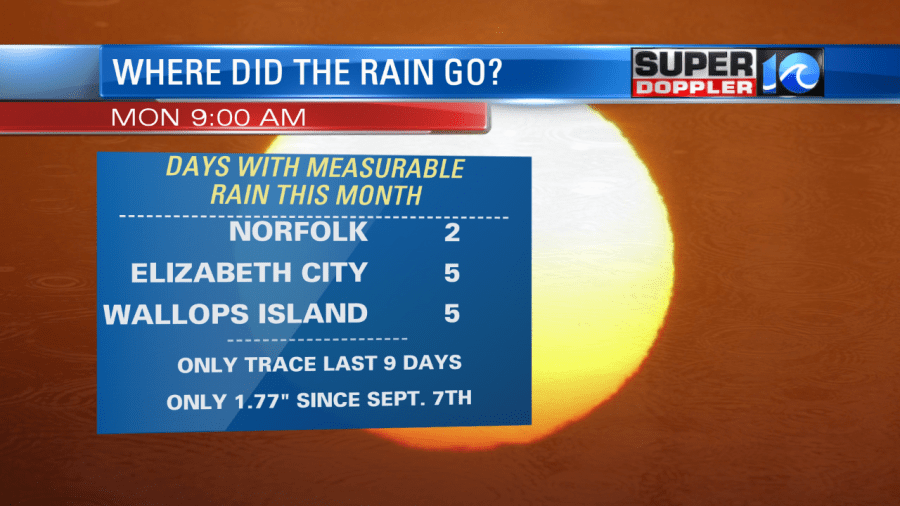
We are actually at average for the month for rainfall in Norfolk as we had two days of decent rain early in the month. However, we are really needing some rain in the short-term. There isn’t much rain in the extended forecast. So we may be going into a drought pattern if this keeps up.
Today is the first day of fall. However, it will feel like Summer outside. High temps will aim for the upper 80s to near 90. The heat index will be in the low-mid 90s. High pressure is just to our south, and that is allowing for a southwest breeze today.

A cool front will drop into the region tonight. This will bring us some spotty showers to the area. Then we could hold on to a few spotty showers tomorrow morning as the front sinks south. Then we’ll clear up through the afternoon. We’ll be cooler tomorrow and Wednesday with highs closer to 80. It will be drier with a north/northeast breeze. The next chance for rain will be next weekend with a few showers possible. Stay tuned.
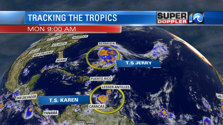
There are 3 systems in the tropics. There are 2 tropical tropical storms (as of this writing) and one tropical depression. Tropical Storm Jerry is south/southwest of Bermuda and it is moving towards that island. It will likely get pretty close to Bermuda, but it looks like it will be at tropical storm strength at the time.

They will probably have some impacts, but they should be much less than when hurricane Humberto moved close to the island. Then the storm will head to the north Atlantic.
Meanwhile, Tropical Storm Karen is more to the south. It is in-between South America and Puerto Rico. Karen is fairly disorganized this morning.
It is moving generally north at a slow pace. It is expected to move towards eastern Puerto Rico and/or near the Virgin Islands by late Tuesday. There are tropical storm warnings already for those areas. The interaction with land could weaken the storm. At least a little bit. If it survives then it will likely keep moving north. At one point high pressure will build to its north. This should slow the system down or even halt it for a time. Then the forecast models split at that point. This is around Saturday. The official forecast and the bulk of the models take Karen to the west towards Florida.
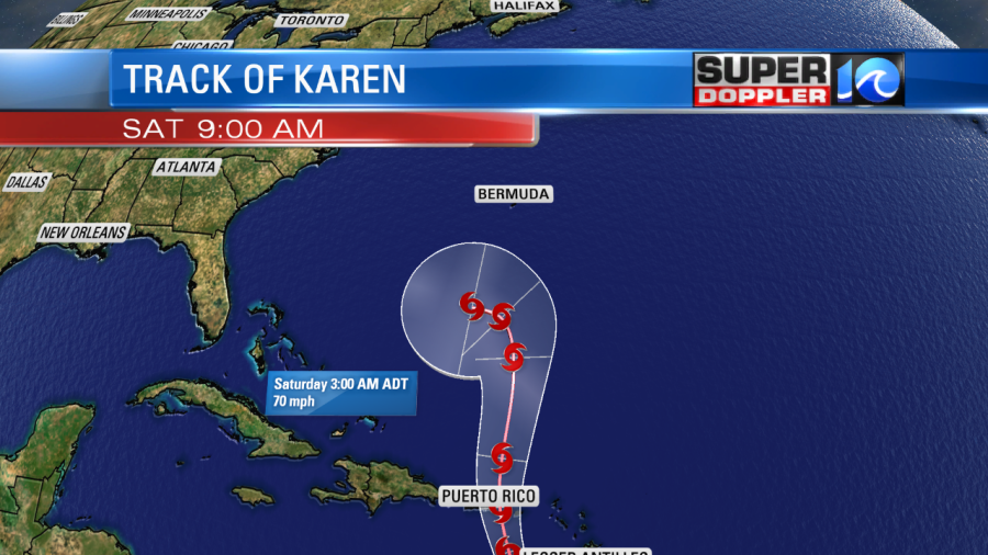
The GFS and European model do keep it weak, but they do both track it towards Florida early next week. Some models do keep it out to sea. Either way we’ll be tracking it closely over the next few days.
Finally, tropical depression 13 has just come off of the African coast. It is moving steadily westward, and it is gaining some strength already. It could turn into tropical storm Lorenzo fairly soon. It is forecast to strengthen into a Category 2 hurricane in a few days, but it is also forecast to move more to the northwest in 4 to 5 days.

If the storm does to move up to that latitude by that time, then it would likely stay out to sea. There’s a lot to track in the tropics. So stay tuned for updates through the week.
Meteorologist: Jeremy Wheeler


