Snow showers will come to an end Saturday, with just a few flurries through the day. Clouds will stick around Saturday with temperatures struggling to get into the low 30s. Wind chill values will be in the 20s through much of the day.
So how did the storm unfold? Overall- pretty well. The snow started Friday evening, with parts of NE NC and Southside seeing a dusting to 1″ by 7 p.m. Through the overnight, the heavier bands of snow arrived as expected and that’s when we really started to see roads get covered and things get slick.
An interesting thing about this storm was how dry the snow was. The reason for that was temperatures for much of the event were in the upper 20s. This results in a drier, finer snow instead of a wet snow.
Most areas picked up a few inches of snow – with reports ranging from 2 to 3″ in Newport News to 4-5″ in VA Beach, Chesapeake and Norfolk. Measuring is a little tricky because the snow has been blowing around, creating some drifts. Below are some of the latest snowfall reports.
Please send your reports to us too! We’d love to see them. With the snow blowing around, the best way to measure is to take a few measurements around your yard and average the numbers together. You can send pictures to us as well through Facebook, Twitter or using the Report It section in the WAVY app.
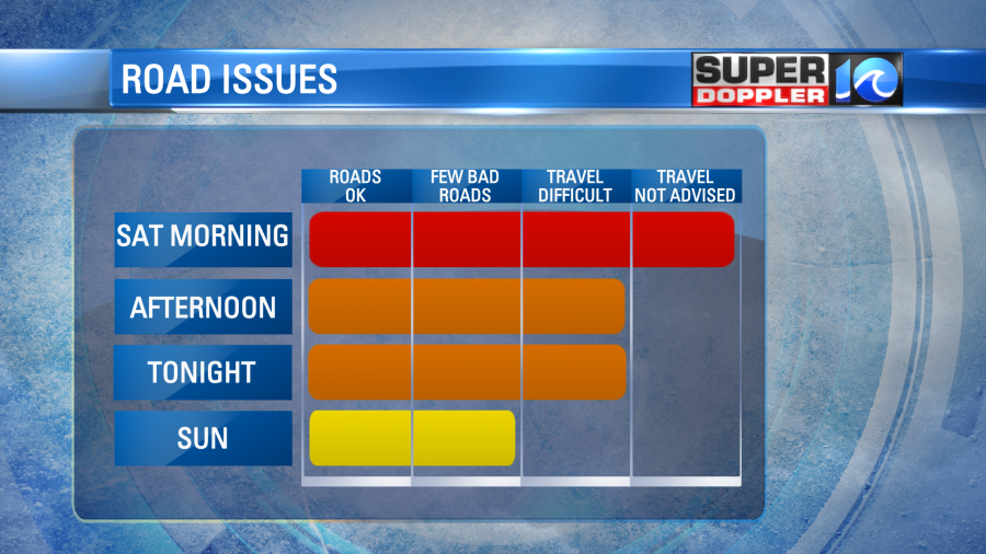
Conditions through the weekend on the roads will slowly improve. VDOT and city crews should be able to start clearing the main roads and interstates through Saturday and into Sunday – but secondary/side roads will likely remain snow covered. Same for residential roads.
Temperatures through Saturday remain cold in the 30s, with 40s returning on Sunday. Partly cloudy skies are expected Sunday.
Meteorologist: Ricky Matthews


