UPDATE: The National Hurricane Center said in its 11 a.m. update a hurricane watch has been issued for from north of South Santee River in South Carolina to Duck, North Carolina, including the Pamlico and Albemarle sounds.
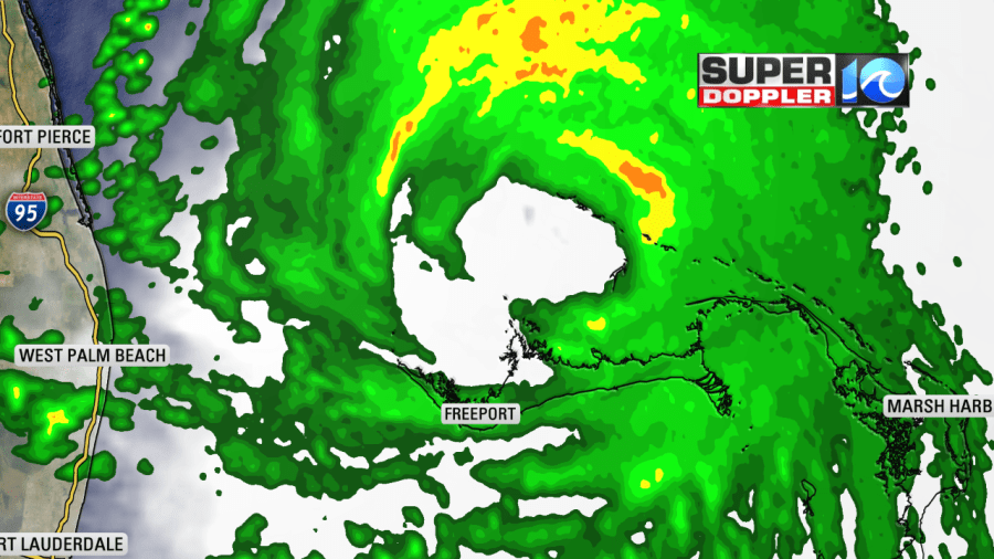
Dorian was stuck in place last night over Grand Bahama Island. There are reports of disastrous flooding and damage coming in from the island. As the storm sat over the same region, it weakened overnight. The eye started getting wider, and it opened up a little (on radar) on the western side.

The wind speed came down to 110 mph, and the pressure increased to 955 mb (millibars of pressure). The land interaction likely weakened the storm. Also, some upwelling could have occurred. This lowered the strength in the short-term forecast as well. Now it looks like it will be a category 3 hurricane as it moves offshore of the Florida coast.

The worst effects will definitely stay offshore as far as Florida is concerned. Through tomorrow, an upper level trough is supposed to drop in and pick up Dorian and drive to the north. By Thursday the upper level winds should start to send it more to the northeast. The stronger upper level winds (wind shear) should weaken the storm The latest forecast has it as a Category 2 hurricane near or just south of Hatteras early Friday morning.

After that point, the forecast sends it out to sea Friday afternoon into the evening. The upper level winds should move the system faster by that time.
The trend in the models is coming together a bit. They are tightly clustered all the way up through Friday morning.

Even the ensembles are starting to cluster together. They are honing in on a track either near or south of Hatteras — and that coincides well with the current NHC forecast. While the center of the storm may pass just south of Hatteras.
Remember, the storm will probably expand a little as it heads up this way. Yesterday, I mentioned that it could interact with a stationary front. Well, today the Weather Prediction Center has that boundary as a weak cold front. That means that it could try to push Dorian a little more east. We’ll see.
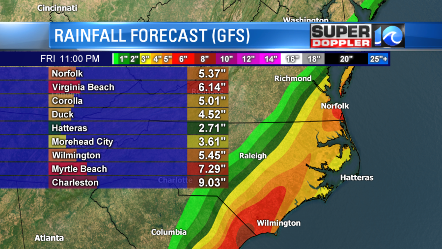
However, the combination of Dorian and the front could also enhance the rainfall well north of the center. Here are two current estimates from the GFS and Euro models for total rainfall.


Keep in mind that: A) This could change if the track changes. B) Sometimes the models tend to overestimate rainfall 3-4 days out. C) There could be a sharper gradient in the rain either along or just north of the track.
We’ll be able to pinpoint that better when it gets in range of the higher resolution models tomorrow.
The wind field will also be able to expand a little. The strongest winds will probably stay offshore since the worst of the winds are to the right of the storms motion. However, there could be some hurricane force winds near the center of the storm.
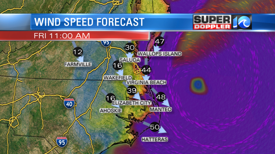
Here is what Future Trak shows for Friday morning.

It has sustained winds near 60 mph over the southern Outer Banks. It has 25-35mph winds in Hampton Roads near the shore. That’s not too bad. However, it does pick up the winds in Hampton Roads (Near the shore and Bay) to over 40 mph for a time Friday morning as the storm starts to move away.

These are tropical storm force winds. Again, these could also change if the track or strength change down the road. So don’t plan on these exact winds just yet, but they should give you an idea of (potential) wind speeds.
As of this writing, the tide/surge forecast doesn’t look too bad for Hampton Roads. The southwest to northeast motion should help. So minor to moderate tidal flooding is possible for now. However, it could be moderate to major towards the southern Outer Banks. I’ll be more specific on that tomorrow. It will also depend on the natural high tide.
So we will definitely see some impacts from Dorian in the region, but the extent is still a little variable yet. I think Hampton roads will be fine, but I am concerned about the southern Outer Banks.
There is another feature that is trackable now. This morning, the National Hurricane Center deemed the disturbance in the Gulf of Mexico as Potential Tropical Cyclone 7.

They have the system forming into a tropical storm and moving west towards Mexico over the next few days. Should be no threat to the U.S.other than possibly the southern tip of Texas. There is another disturbance in the eastern Atlantic that is likely to form soon.

That one is moving to the west, and we’ll track it as it forms.
The weather locally is quiet for the next couple of days. We have high pressure to the north today with a weak cool front slowly sinking south.

We’ll be slightly cooler with highs in the low-mid 80s. We’ll be partly cloudy with isolated showers/t’storms this afternoon. Then partly cloudy tomorrow with highs in the upper 80s. There is a high threat for rip currents at the local beaches. The surf looks good, but experienced surfers in the water today only.
Stay tuned for updates to all of this through the day.
Meteorologist: Jeremy Wheeler


