Hopefully, you heeded my advice about getting things done yesterday that you need to do if it involved heading outdoors. Today we will have rain, storms and wind. Tomorrow we’ll have strong winds, a possible brief mix, and crashing temperatures.
Lets start off with today. High pressure is moving away to the north with an area of low pressure creeping up from the south. There is also a warm front moving up from the south.
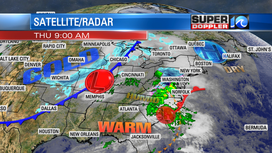
There is a powerful cold front over the Midwest with a strengthening area of low pressure moving along the front. This is causing a lot of snow showers to fall from Arkansas up to the Great Lakes. This will be a big problem area for travelers today.
It’s not so much that there could be some heavy snow. The problem is that there will be a lot of wind and cold temperatures there too. So blowing snow and blizzards will be the issue. That will disrupt air travel as well as driving. Meanwhile we’ll have a lot of rain in our region today.
Rain will become pretty widespread as we go into the midday hours.
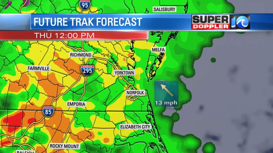
Then this afternoon there will potentially be some heavy rain and a few thunderstorms.
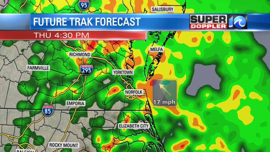
The threat for severe weather will stay mainly to our south. However, the winds in the viewing area will gust up to 30mph (severe winds are 58mph or stronger) even without any thunderstorms. This could cause some problems during the lunch hour and the evening commute. At least it will be warm outside. High temps this afternoon will be in the low 60s.
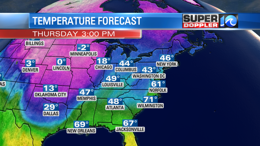
Look at the contrast between our temperatures here and over the Midwest. That colder air will slide east, and that will create a huge clash of the air masses. That is why the system in the Midwest will have so much energy. Also, a huge upper level trough will come down and also give energy to the system.
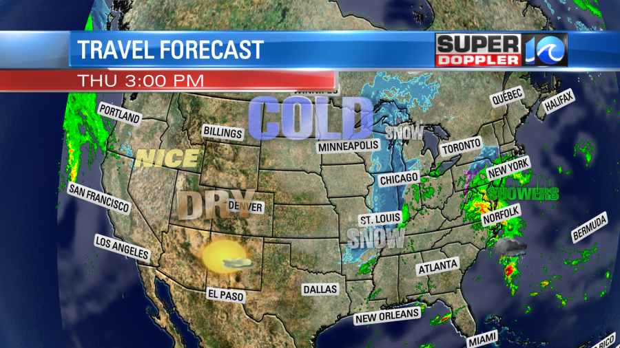
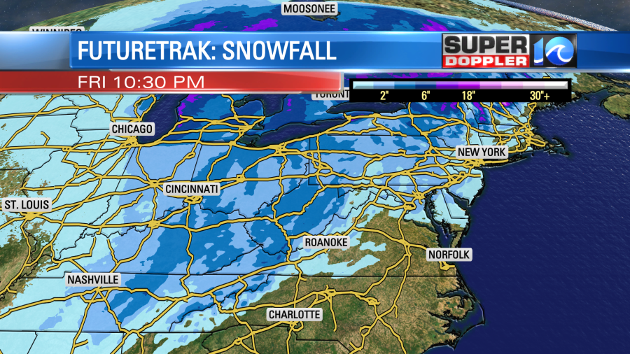
Tomorrow as the area of low pressure moves northeast it will produce a lot of snow from the Ohio River Valley up into the Great Lakes and southeastern Canada.
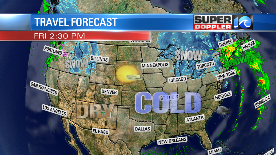
Rain will move up into the northeast states, but that will turn into frozen precip through the late afternoon into the evening. There will be some more precip over the northern Rockies, but a big part of the U.S. will be dry. There will be accumulating snow to our north and west, but nothing for our region.
Having said that…There will be a few rain showers tomorrow morning in our area. Temps will start off in the 50s.
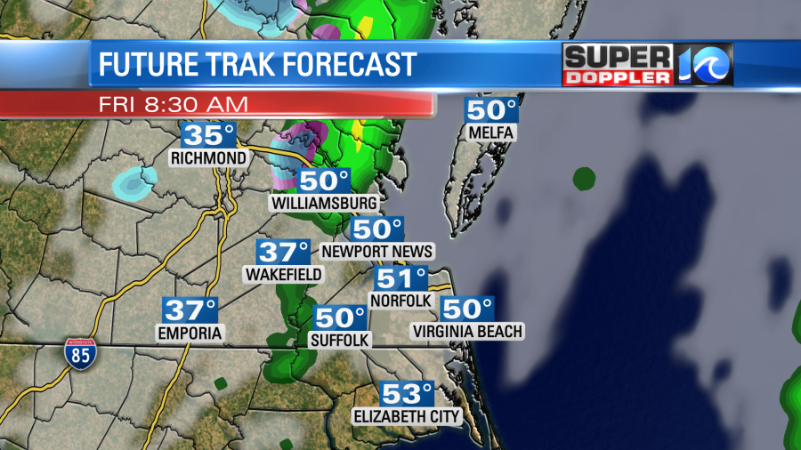
The strong cold front will arrive in the morning. This will drop the temps immediately. It will cause a small area of a wintry mix, but this should have hardly any impacts on the region.
Drier air will swarm in fast from the west along with the colder air. So we’ll dry out through the late morning and midday hours. Then wind and cold become the headlines. Winds will gust out of the west at about 40-45mph.
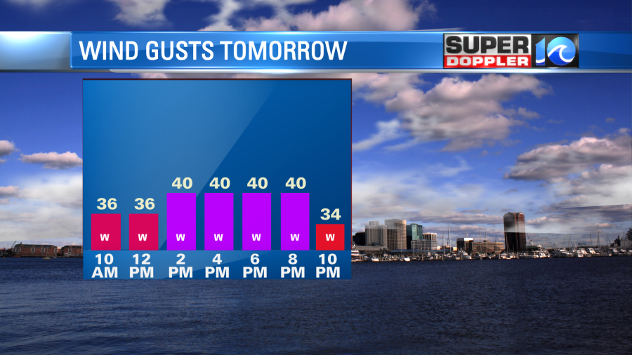
The temperatures will fall from near 50 in the morning to near 30 in the afteroon.
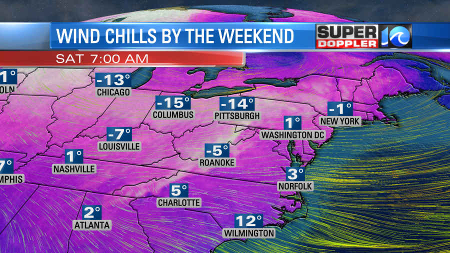
We’ll be mainly dry, but there could be a few flurries in the region between late Friday and Saturday. On Saturday we’ll start off super cold (for this area). Temps will drop all the way down to the teens, but the wind chills will be in the single digits.
So up to this point there are several possible hazards that we need to prepare for.
- Heavy rain today could create some isolated spots of flooding later today.
- The heavy showers and scattered thunderstorms could impact the evening commute.
- Winds tomorrow could be strong enough for some power outages. This could be a big problem with the colder air arriving. So you may want to gas up the generator. Get some extra warm blankets and candles ready just in case. Also, SECURE YOUR BLOW UP HOLIDAY DECORATIONS!
- The strong west wind will create some minor to moderate tidal flooding on the Bay side of the Eastern Shore.
- Temps will be cold enough Saturday morning that we’ll need to slow-drip the faucets overnight Friday into Saturday.
Through the day Saturday we’ll have a mix of sun and clouds. I can’t rule out a few flurries, but it’s a low chance. Winds will gust out of the west at 40-45mph. High temps will only be in the low 30s. Wind chills will be in the teens and 20s through the day.
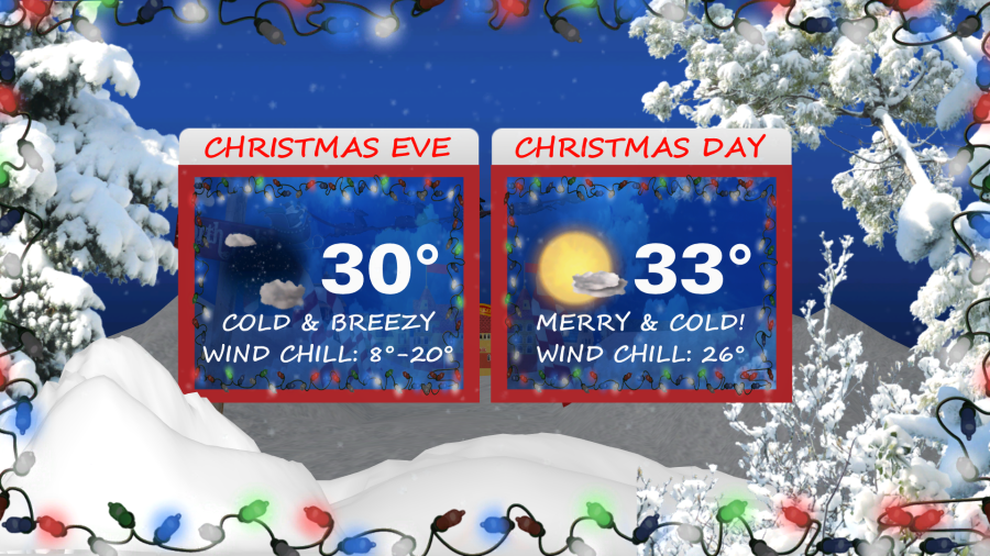
We’ll stay cold Christmas Eve in the evening, but the winds will start to come down a little. It will be tough for those going to evening services. The Temps will be in the 20s and 30s, but the wind chills will be in the teens and 20s. Then temps will drop down the teens again Christmas morning. High temperatures will only be in the low-mid 30s in the afternoon. At least it will be dry for travel, and there will be less wind.
There’s more to talk about with the extended forecast, but that’s a lot to take in here. So I’ll leave it at that. Please be safe in your travels.
Meteorologist: Jeremy Wheeler


