UPDATE: Soaking rains for parts of the region will be moving in overnight, but our impacts will be vastly different depending on your location. The majority of the rain and wind will be confined to northeast North Carolina as Idalia interacts with an approaching cool front.
North Carolina and the Outer Banks
Expect rain, heavy at times, to fill in later tonight, lasting through the night into early Thursday morning. Winds will begin to pick up overnight with gusts to 40 and 50 mph.
A few spin-up tornadoes are also possible in the early morning hours for those down towards Hatteras and Ocracoke.
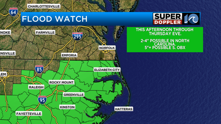
By late morning, most of the heavy rain will be starting to ease, but by that time rainfall amounts may be upwards of 2 to 4 inches, maybe more. Localized flooding is possible, plus, along NC-12 south of the Oregon Inlet, ocean overwash is expected for at least the morning and evening high tides tomorrow.
Hampton Roads
Expect a damp and dreary day with blustery winds. By tomorrow morning, some consistent rain will inch into the Southside, moderate to occasionally heavy. Then by late morning, most of the rain will be broken or scattered in nature.
Across the Peninsulas and the Eastern Shore, there should hardly be any rain at all. Winds will be gusting to 25 to 35 mph from the early morning into the evening hours.
All of us will see the sun try to make a return around sunset Thursday, with dry and refreshing conditions moving in Friday. It’ll remain blustery throughout Friday but winds will back off into the night. Highs should hold in the 70s for Friday and Saturday with sunshine guiding us through the holiday weekend. Temperatures should reach 90 degrees by Labor Day.
_____________________________________________________________________________________________________
Tracking Idalia
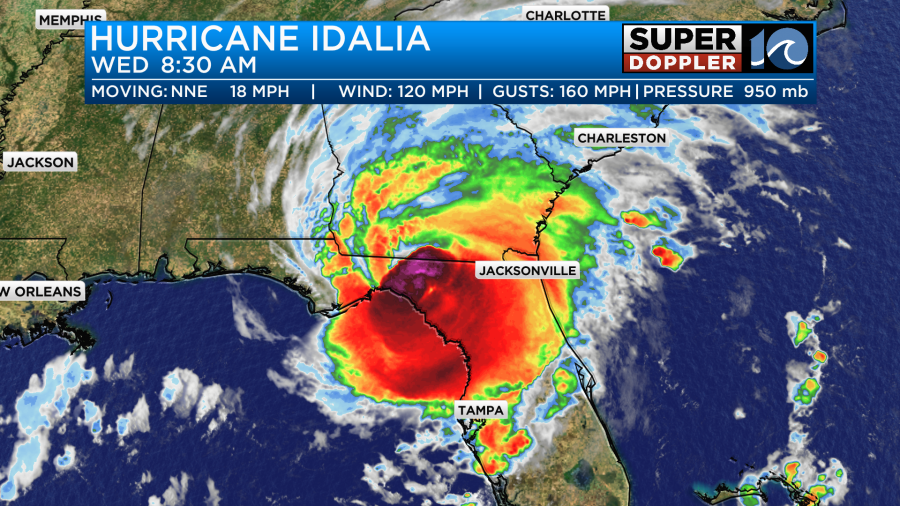
At one point, sustained winds were up to 130 mph. However, this status was brief, as it had weakened slightly by the 7 a.m. hour to a high-end Category 3 hurricane. This was due to an eyewall replacement cycle. Keep in mind that there is little difference between a strong Category 3 and a minimal Category 4. Regardless, those strong winds pushed ashore this morning as the storm made landfall around 7:45 a.m. near Keaton Beach, Florida.
There were some strong gusts to around 70 mph near Cedar Key, Florida.
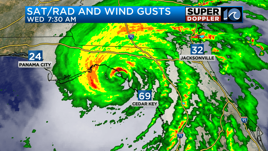
I was surprised that the gusts weren’t higher there at Cedar Key, but the strongest winds were confined to a small area around the eye, so maybe that’s why. Despite that, the surge was able to travel far south.
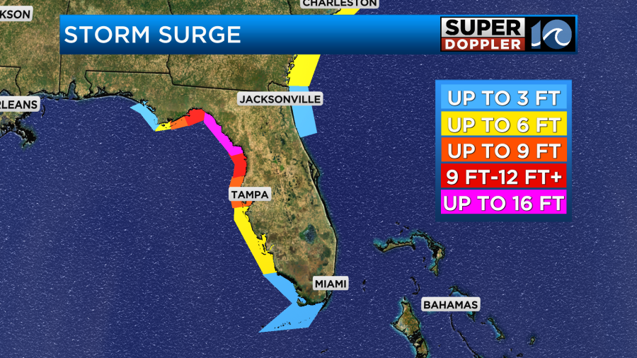
They had water levels of about four-to-six feet down to Tampa. There were much higher levels around the Big Bend area, but under the highest forecast shown above.
Idalia will move northeast and inland Wednesday. It will bring hurricane force winds to northern Florida and southern Georgia.

There aren’t any large cities in its short-term path, but it will cause damage to many of the small communities there. Eventually it will grind down over land.
By late tonight it should get down to a tropical storm. Tomorrow, it will turn more to the east, and it should pass to our south as a tropical storm.
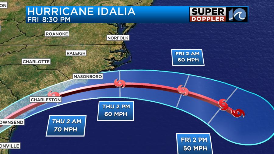
There is growing confidence that it will pass just south of our region as the models are coming into better agreement, and the track width is getting smaller.
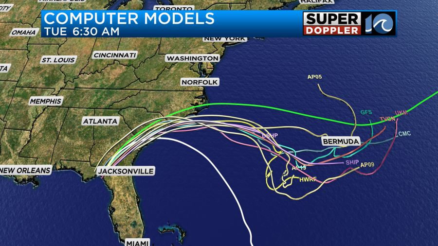
However, Idalia will interact with a front that is over us Wednesday, and an area of high pressure to our north.
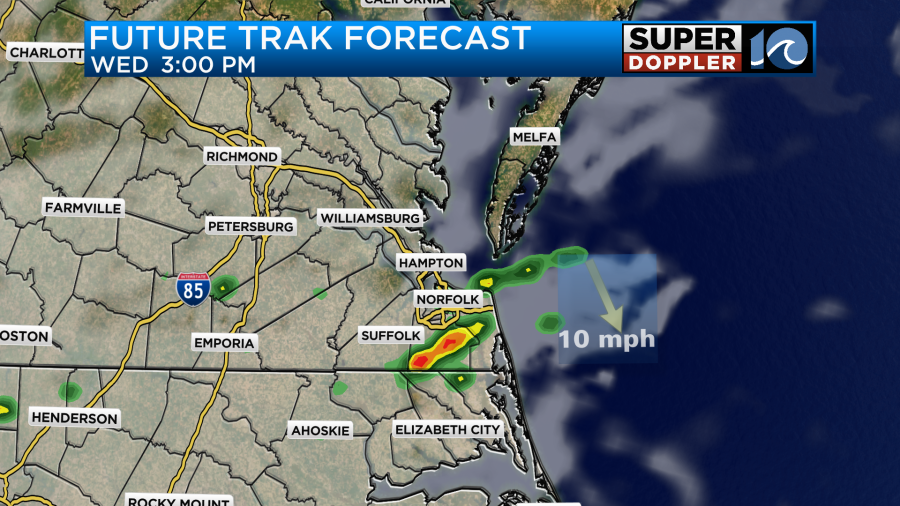
This will both guide Idalia and also allow the rain and wind to get more north of the storm. Normally, tropical systems are somewhat compact, but this system will be able to spread out a bit. It will almost be a hybrid system, so the rain tomorrow will cover most of North Carolina, and scattered showers will fall over southeast Virginia.
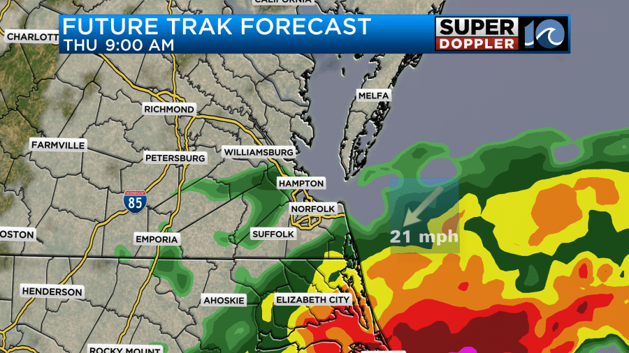
The rain should taper off later in the day, and it should end by tomorrow night. Rain totals should be highest down across the southern Outer Banks, as that area will be closest to the storm. However, two-to-four inches of rain will be possible over other parts of North Carolina.
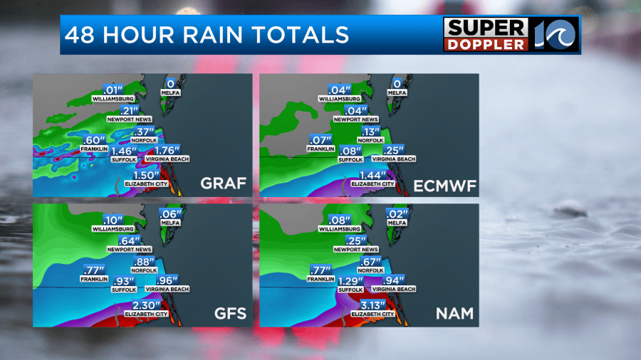
Hampton Roads should get about a half-inch to 1.5 inches of rain, with much less north of the metro area.
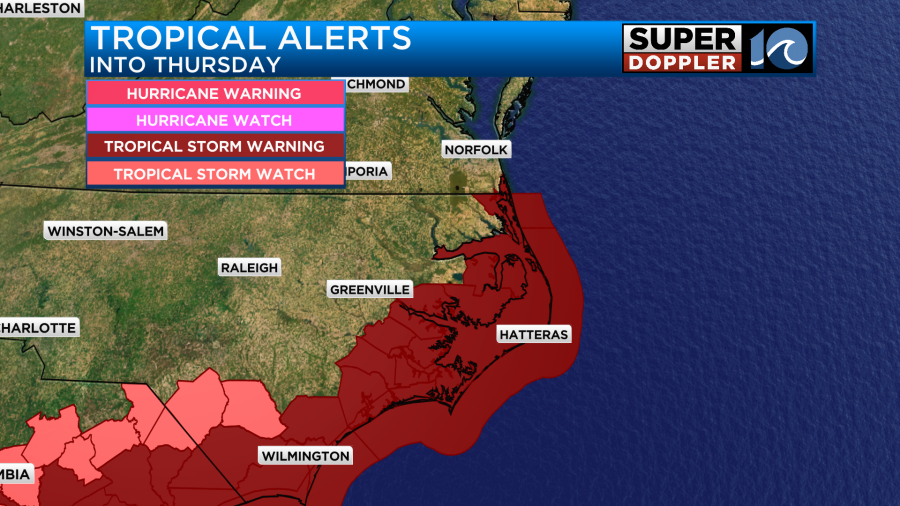
There is a flood watch in effect for all of eastern North Carolina.
Wind will be light and variable Wednesday. However, it will pick up by Thursday morning.
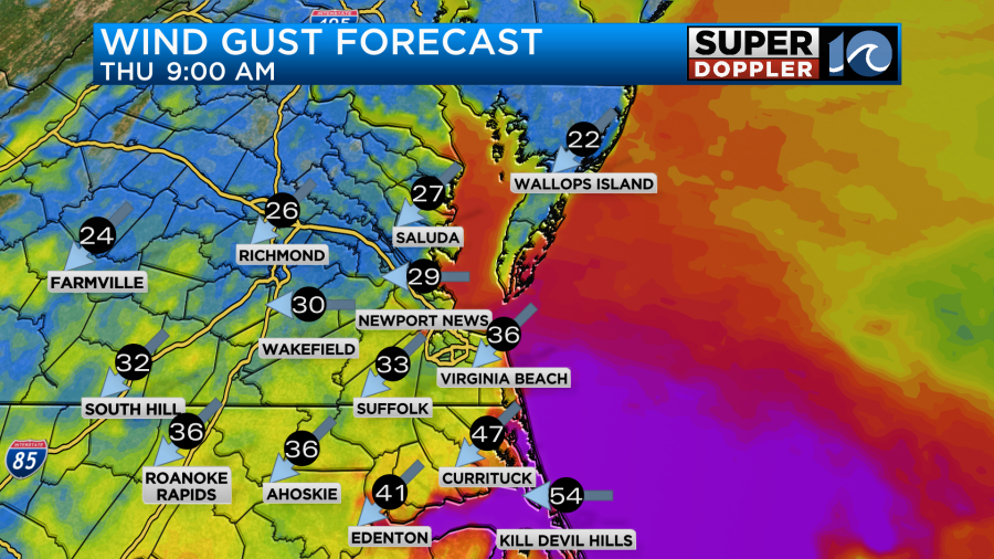
Through the day, winds will gust up to 25 to 35mph near the shore, and gusts could run up to 45 to 50 mph over the Outer Banks. Winds will decrease by Thursday night into Friday morning. There is a tropical storm warning through early morning Friday.
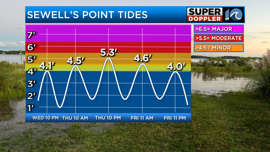
There may be some minor tidal flooding, but my latest thinking is that the tidal flooding shouldn’t be too high since the storm will be moving pretty quickly. The northeast winds will last before and after the storm due to the pressure gradient between Idalia and the high to the northwest.
There are already some high waves coming in from Hurricane Franklin, so the combo of that and the northeast wind could create some big surf, ocean overwash (OBX), as well as some beach erosion. There may be some minor tidal flooding after the storm moves out to sea. Here’s the latest forecast, but I wouldn’t be surprised if the numbers change before Thursday.
We’ll have updates on this system throughout the day.
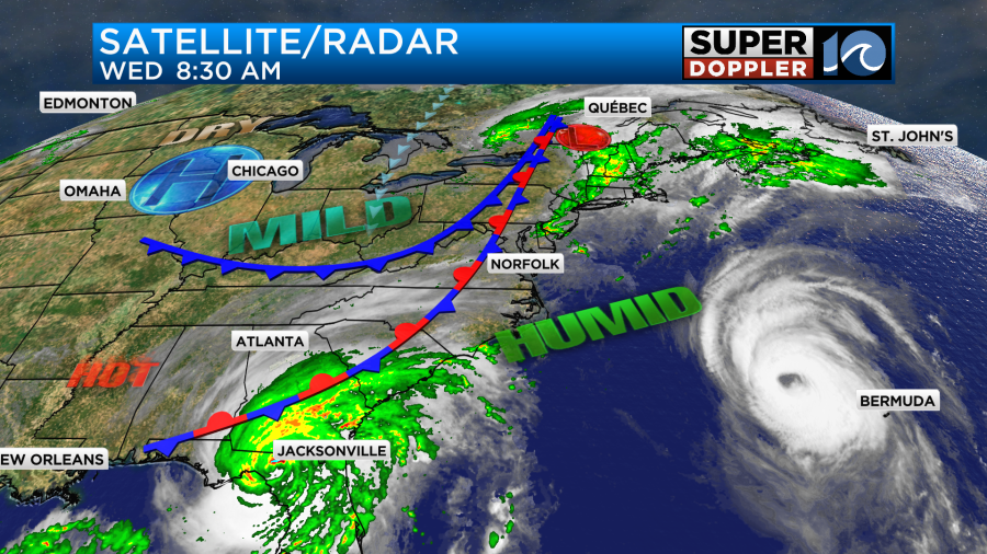
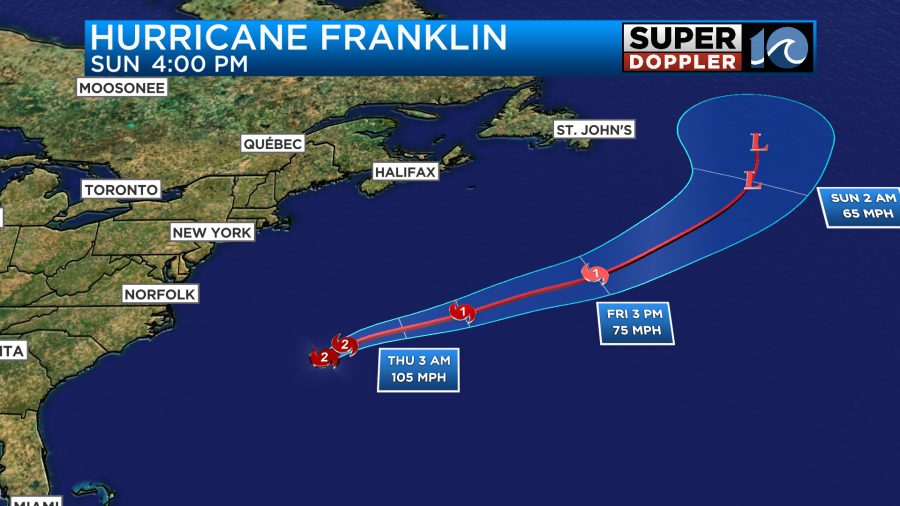
Meanwhile there are two other systems in the Atlantic Basin. Hurricane Franklin is northwest of Bermuda and moving to the northeast. Tropical Depression 11 is over the middle of the Atlantic and moving north.
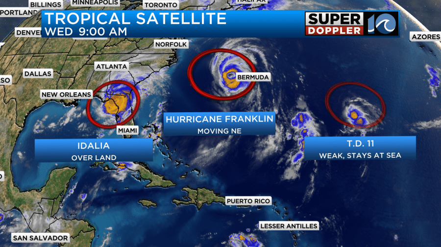
Franklin has a huge eye on satellite. It has really opened up. The eye is twice as large as Bermuda. It was a Category 2 storm at the time of this writing. They will get some tropical storm forced winds over Bermuda Wednesday. The system will pick up some speed and move to the northeast over cooler waters. So it should gradually weaken and become non-tropical in a few days.
This system has brought us nice swells over the last 24 hours. It got even better Wednesday morning.
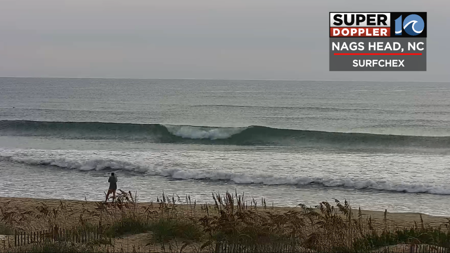
However, this has also continued to bring us a high risk for rip currents. That also continues Wednesday.
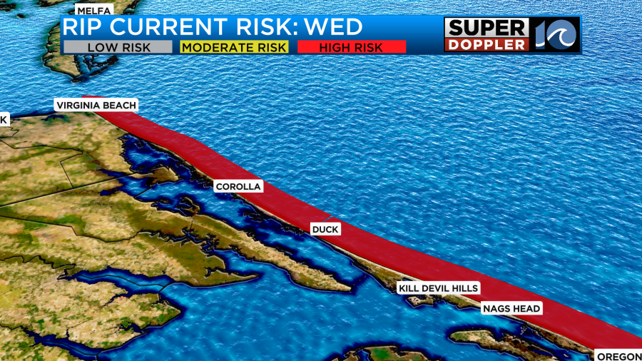
Some folks may not be able to get in the water past their knees over parts of the Outer Banks — experienced surfers only Wednesday.
Tropical Depression 11 is barely adding anything to this. It will basically work slowly northward, and then it will fall apart within the next 36 hours.
Locally Wednesday, we’ll be partly to mostly cloudy with some scattered showers forming this afternoon. There will also be a few thunderstorms.
There could be a few heavy downpours due to the high humidity and the front eventually moving in from the northwest. High temps will be in the mid-upper 80s, and there won’t be much of a breeze.
Thursday, high temps will only be in the 70s due to the clouds, showers, and wind. By Friday we’ll have clearing skies and a bit of a breeze. High temps will still be in the 70s. It should actually be awesome outside! The the weekend looks good. Highs will be in the upper 70s Saturday. We’ll be in the mid 80s Sunday.
Stay tuned for updates.
Meteorologist: Jeremy Wheeler