We will be tracking an area of low pressure over the Carolinas today. This system will have a sizable impact on our weather over the next 48 hours. Whether it becomes tropical or not. Today the low is moving between eastern South Carolina and coastal North Carolina.

The low is actually riding along a stationary front. We have high pressure offshore. There is a lot of humidity in the region.
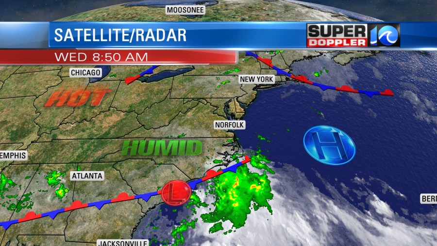
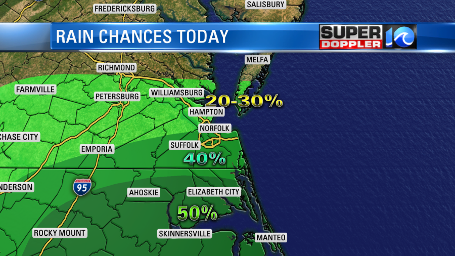
We’ll have a mix of sun and clouds today. The low is close enough that we’ll have some scattered showers and a few storms in the region. The higher chances for rain are definitely to the south. There will only be spotty showers from Hampton and Cape Charles northward.
High temps will rise to the upper 80s to low 90s with some cooler temps near the shore. However, it is very humid outside. Dew points are in the low-mid 70s with a few upper 70s here and there. So it will feel like the low-mid 90s with the heat index. Luckily, there will be an increasing onshore breeze (easterly) at 5-15mph. So that will help eventually.
Tomorrow the low will push up in to our region. The track is tricky, and the exact track will determine the rain totals. For now it looks like it will move up right along the coast. However, will it move just offshore, or will it move inland a little bit? If it moves more over the water, then it could become a tropical system. There is a moderate to high chance for that to happen. However, our Future Trak model has it over land a little bit more. So it has been showing a lot of rain in our area on and off through the day.
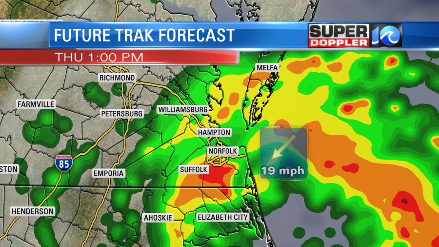
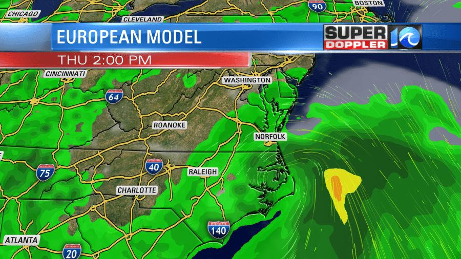
It has very heavy rain for a time. Keep in mind that most other models have the low just offshore or at least much broader. Here is the European computer model’s forecast:
Our Future Trak model forecasts the highest amounts of rain in our region. It has a solid 1-2″ with some spots up to 3″ or higher.
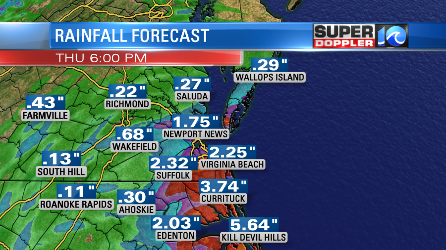
If this were to happen, then we may have some localized flooding. The GFS and European models are broader, and the NAM keeps the low a bit more offshore. So they keep the heaviest rain just offshore.

If you blend the models then I think we basically will have a big area of rain that will move in tomorrow, and it should cover a large part of the region. The heaviest rain may be offshore or just along the coast. So that could potentially be over the Outer Banks up to Virginia Beach. There may be a sharp cutoff as you go west of the metro. (Maybe even over the metro). We’ll have updates on this later today. Hopefully, the models will all come together by this afternoon or evening.
The wind will increase tomorrow with either scenario. We’ll have an east/northeast breeze at 10-15mph. Gusts will be up to 25mph. The breeze will be welcome. Temps will be in the low-mid, but the humidity will be just as high as today.
The low will slowly move to our north on Friday. We’ll have a mix of sun and clouds with a few pm showers and storms. High temps will be in the upper 80s to near 90. Over the weekend an upper level disturbance will move over our area. This will bring us some scattered showers and storms each day. Mainly in the afternoon. There’s been a lot of heat to our west that will push east. So we’ll have high temps in the 90s with high humidity.
Stay tuned for updates.
Meteorologist: Jeremy Wheeler