I’ve been pondering about how much I should talk about Florence in today’s blog. Over the weekend I tried to work out what happened with the system in my mind and how the forecast had changed over time. What happened? Did we truly dodge a bullet?
The short answer is yes! We did dodge a bullet. The testament to that is what’s happening now over parts of North Carolina including Wilmington. A few days ago that extreme weather looked possible for our region. In the end it wasn’t that far away from us meteorologically speaking. We did have some rain in the region, but we were spared the flooding. We did have some wind gusts to over 60mph over parts of eastern North Carolina, but it never was too strong in Hampton Roads.
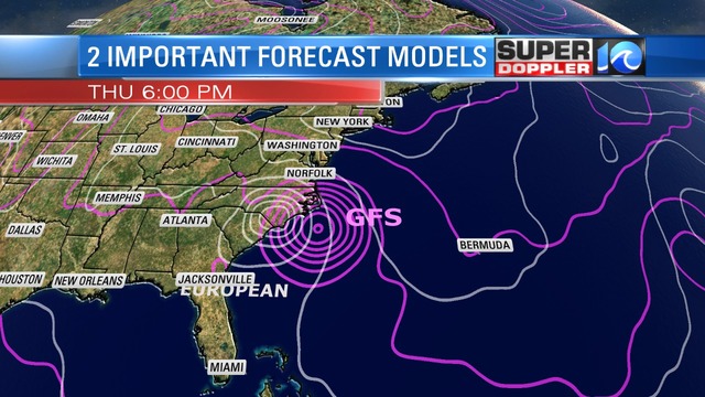
Several days ago the computer models showed a lot of uncertainty in the track. About 8-9 days ago the European computer model actually had Florence hitting Hampton Roads as a possible major hurricane while most of the other computer models had it staying out over the Atlantic. Through time the models all shifted west. So for a few days the European model had the system moving more west while a cluster of other models had it striking near Cape Hatteras. Strong high pressure had built over the north/central Atlantic, and this was expected to steer Florence towards the North Carolina coast. Over the course of a couple of days it finally became obvious that the European model was much closer to being correct. It handled the surrounding synoptic weather better than many of the other models. It hadn’t strayed too much from 2-4 days before landfall while the GFS model did waiver.
Finally around midday Wednesday the GFS model had a huge shift west. There was still a possiblity that Florence could pass very close to Hatteras which would have still been a bad scenario. In the end it passed south enough of that area that it was also spared the worst of the wind and surge. As you then know, Florence made landfall Friday morning near Wilmington NC, and it has caused devastation for that entire region. About 30 inches of rain has fallen over parts of southern North Carolina.
Looking back its easy to say that we should have all followed the European model. However, the GFS model had hung tough to its track for about 2 or 3 days. There were other models which also showed the more eastern track until about Wednesday.

I will say that the National Hurricane Center did side with the Euro for the bulk of the time, and so they did do an excellent job of forecasting the track.
We did go with the lesser impacts forecast from Wednesday night into Friday. However, even the moderate impacts were muted in Hampton Roads. We ended up with lots of rain bands in the region instead of a big steady rain. Some of the more consistent rain fell over parts of inland North Carolina. I think one big forecast problem was that the computer models had basically connected the dots between the rain bands when it came to forecasting amounts. They were calling for about 3-5″ in Hampton Roads when we actually only picked up about 1-2″ scattered about. Some places had much less. Rain was also overforecast over northeast North Carolina. This was on many levels too. The models, the Weather Prediction center, the National Weather Service, (ME!) all forecast more rain than fell. On Friday I did notice that there were huge patches of rain offshore, but they kept falling apart as they moved over land. I had never seen that in a tropical system before, and I’m not sure why that happened. It wasn’t due to a lack of humidity. That’s for sure.
Since the wind wasn’t as strong as forecast, the tide was also lower. In Hampton Roads the forecast was for about 5.5 – 6ft. As it got closer the tide forecast started dropping. So we ended up with a tide at Sewell’s Point a bit above 5 ft. This was minor. Not the moderate that was expected. Even the tide over the Albemarle didn’t seem to swell as forecast. However, ironically…today there has been nuisance to minor tidal flooding along the Albemarle Sound and the adjacent rivers. There is also a little over souther Virginia Beach. This is due to the winds turning more out of the south/southeast. Last week the National Hurricane Center had called for a 4-6ft storm surge over the southern Banks even up until midday Friday. Watching our reporter Jason Marks from that area, it seemed like that also didn’t come to fruition.
So it was a poor forecast on several levels, but there was also some misperception. Many people thought that hurricane Matthew was going to happen again. Thursday into Friday we tried to tell folks that it wouldn’t be that bad. Especially with the tide forecast. Hurricane Matthew never did strike here. It’s tide never got above 6ft in Hampton Roads. However, we had a widespread flash flood partially caused by the interaction of a stationary front at that time. That fell on top of the moderate tide, and it had nowhere to go. Matthew also became sub-tropical as it moved northeast of Hatteras. This allowed its winds and rain to spread out over a larger distance. However, Florence stayed completely tropical. There was a weak stationary over our region during Florence. But it was a very weak front, and there was little interaction. So while the rain from Florence spread out, it’s rain shield only ran up to about Bertie county.
Going forward there is one big hope for the future. The GFS model is currently being upgraded. It is going to totally change. They are running the new version already. It will be available to the public next year. I’m hoping this overhaul will finally let it compete with the European model. It could potentially change all aspects of forecasting, but we’ll see.
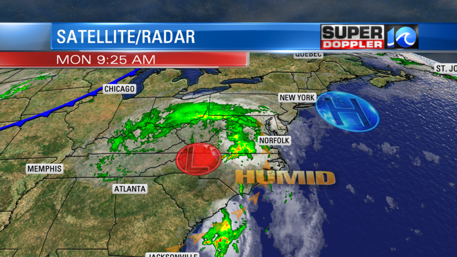
Today tropical depression Florence is slowly spinning over western North Carolina. Heavy rain and moisture are moving up along its eastern side.
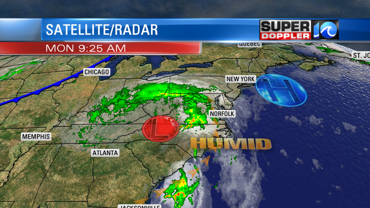
The system will move north today, and should be in Pennsylvania by Wednesday. As the system moves to our north, it will allow our local winds to turn out of the west/northwest. This will finally allow us to dry out. We’ll have scattered showers today and tomorrow before the wind change.
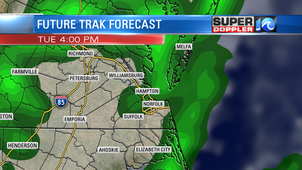
We could see about a quarter to three-quarters of an inch of rain through Tuesday evening. On Wednesday the dew points will drop into the 60s. It won’t be bone dry, but it will feel much much better than the past couple of weeks. This feels like it has been the most humid Summer since I’ve been here. So Wednesday almost feels like a finish line. Temps will also drop. Highs will be in the low 80s Wednesday and Thursday. Lows will drop to the 60s. The first day of Fall is Saturday already. Hopefully, it will start feeling like it for a while.
Meteorologist: Jeremy Wheeler