
We broke and tied several records in the area yesterday. In Norfolk we tied the record of 79 degrees. We were just one degree shy of 80. However, in Elizabeth City they did hit 80 degrees. This broke the old record of 77 (2014). It was even more impressive at Wallops Island. Despite being on the Eastern Shore (which is influenced by the Bay and Ocean), they still managed to hit 78 degrees.
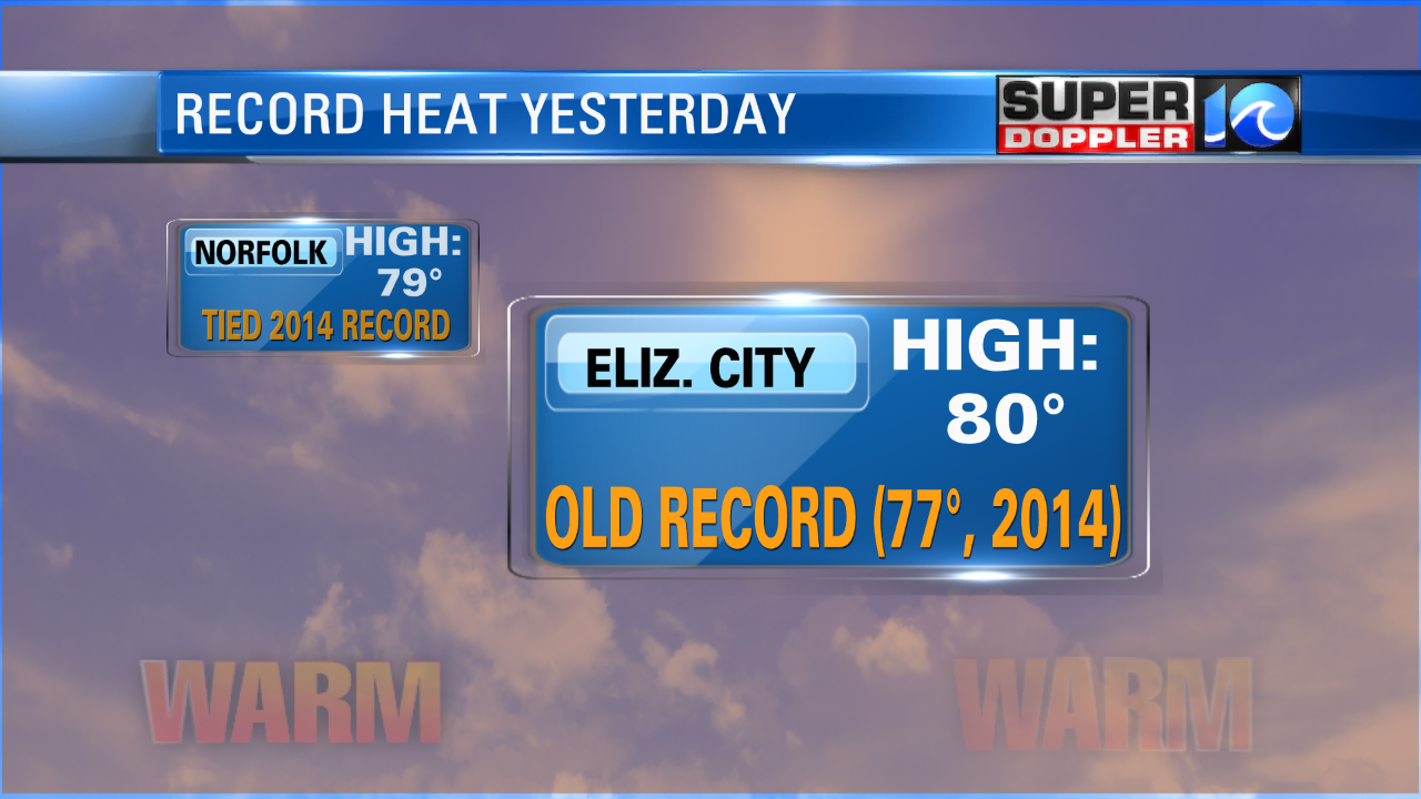
This smashed the old record of 69 degrees (2002).
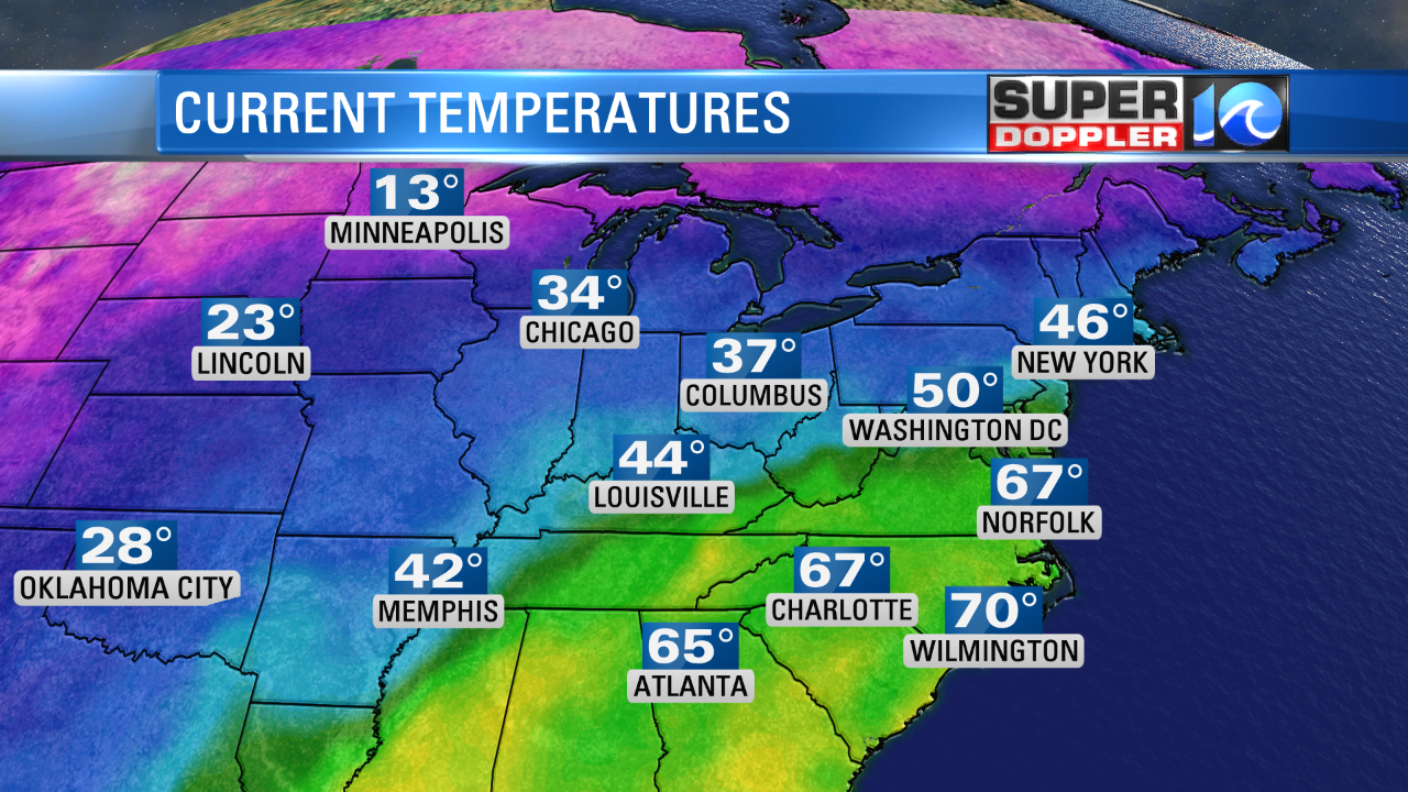
It was warm and a bit humid, but it was breezy. So it felt pretty nice out. We will still be warm today, but there is some cooler/colder air just to our north.
A cold front had made it into Washington D.C. and New York, but it is stalling out.
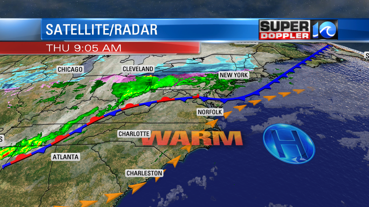
The front may sink a little farther south today, but it should stay just north of the viewing area. There could be some isolated showers closer to the front with a stray shower or two in other parts of our region. Skies will become partly cloudy today after some scattered clouds and fog this morning. High temps will aim for the mid 70s. We’ll be just a couple degrees shy of yesterday. I’m calling for 75 degrees in Norfolk. The record for today is 77 degrees (2003). There will probably be some upper 70s inland with cooler temps near the shore. The wind is only forecast to be out of the southwest at 5-10mph. Yesterday the breeze was strong through the day. That stopped any sea breezes from forming. So today there may be a sea-breeze kicking in this afternoon. We’ll see. Bay temperatures are in the upper 40s to near 50. Some scattered showers will move into the region this evening. The cold front will finally march south into Hampton Roads.

I think the showers will be a little farther south than the model shows by that time. The front will drop just to our south by tomorrow. It will stall out. We’ll have more clouds and some isolated showers. There might also be some patchy drizzle. Winds will be out of the northeast at 8-12mph. This should keep the temperatures down. We’ll top off in the upper 50s, but some locations could reach the low 60s. This will be very temporary. The front will lift back north as a warm front by Friday night. So on Saturday we’ll have high temperatures returning to the upper 70s. Skies will be partly cloudy. There may be some isolated showers. There will be a little better chance for showers on Sunday with more clouds. High temps will still manage to warm up to the upper 70s. We’ll cool things down into next week. High temps will be in the 50s and 60s through mid-week.
In world news…I found this neat article that shows some very interesting cloud features over the Pacific Ocean. Recently, ships…yes ships…helped to create these long streaks of thin clouds. At least according to the article. We are talking for hundreds of miles. Check out the article with a satellite image of the feature: Long Cloud Streaks Over The Pacific.
In other news…Apparently sea level rise is not constant. In fact a new study by several institutions recently noticed that there has been an acceleration in sea level rise over the last couple of decades. The study was published in the Proceedings of the National Academy of Sciences. Based off of the current acceleration, the study says that sea level could rise 26 inches by the year 2100. Old Dominion University is cited in the Study. It is a scary notion. Here is the article with more information. Sea Level Rise Acceleration.
About a month or two ago I posted an article about how there may have to be adjustments in sea level forecasts due to the weight of the extra water pushing down the sea bed. Over the last few years, I started to think about that possibility. Here is an article that quantifies that effect. Weight of increased water affects seafloor depth.
Sea level rise is debated by some scientists. Here is one article with some different theories on the subject. Sea level rise skepticism.
Time will tell.
Meteorologist: Jeremy Wheeler


