Flawless would be the only way to describe the weather over the last few days – the Super Doppler 10 Weather Team is hoping you got to take advantage over the weekend because it’s set to change as we move forward into the workweek.
Humidity slowly creeps back into the region, especially by Wednesday, along with temperatures returning into the mid to upper 80s. Wednesday will also be the day we welcome some much needed rain – scattered showers and a few thunderstorms could develop by late day.
Now tomorrow, Tuesday, will be our transition day into the summer humidity and amidst the transition, not only will humidity and warmth move into the region but so will wildfire smoke.

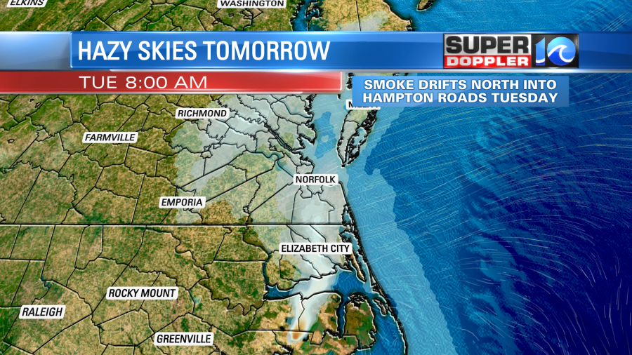
A several hundred wildfire burning in Hyde County, North Carolina, started on Sunday afternoon and has been burning since. Known as the Ferebee Road Fire, it’s believed to be started from a lightning strike during the thunderstorm activity on Thursday or Friday of last week. The smoldering tree or brush was then stoked & flared by the cool, dry and fresh breeze over the weekend.
Currently, the smoke from the flames are being fanned to the south, but when the breeze changes out of the south, it’ll pull some of the smoke up towards Hampton Roads. It’ll likely create some hazy skies for the sunrise on Tuesday, mainly for those in northeast North Carolina.
A good reminder that the chances for rain later Wednesday are a welcomed site.
Meteorologist Steve Fundaro