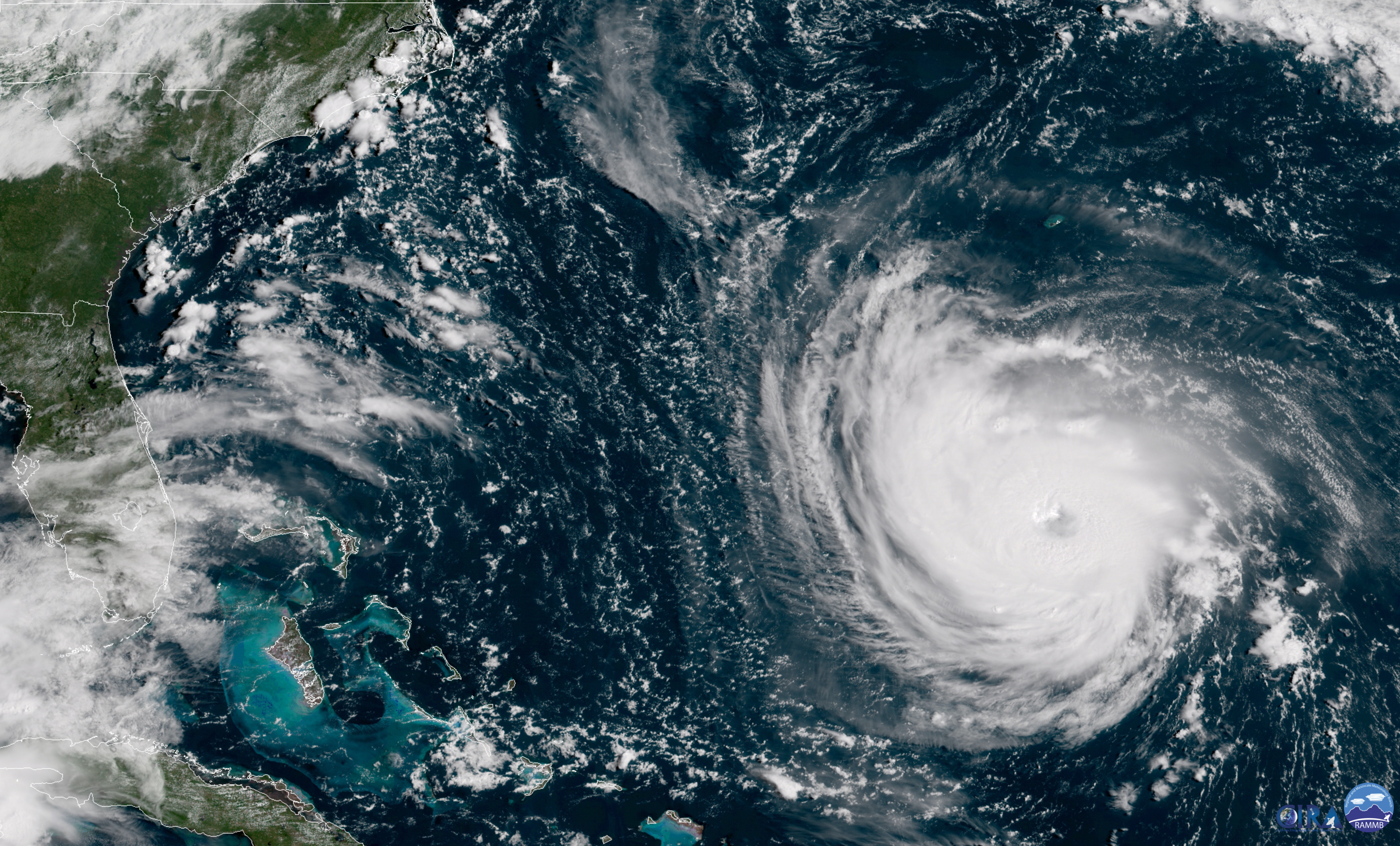
PORTSMOUTH, Va. (WAVY/AP) — Hurricane Florence is now a Category 2 hurricane, but it’s still expected to bring devastating storm surge and rainfall to the Carolinas and potential tropical storm conditions to Hampton Roads.
As of 11 p.m. Wednesday, the storm was centered 280 miles southeast of Wilmington, North Carolina, moving at 16 mph. It’s a Category 2 storm with maximum sustained winds of 110 mph, and is expected to make landfall early Friday morning at Wilmington. It’ll weaken to a Category 1 storm with 90 mph by 8 a.m. Friday. The storm is then expected to shift southwest toward Augusta, Georgia.
Extremely heavy rain is expected to fall in that area, with upwards of 40 inches of rain in spots. Hampton Roads will likely see anywhere from 3 to 7 inches of rain.
Motorists streamed inland on highways converted to one-way evacuation routes Tuesday as about 1.7 million people in three states were warned to get out of the way of Hurricane Florence.
Blog: Florence Forecast Keeps Trending West
The National Hurricane Center said Wednesday Florence is expected to bring life-threatening storm surge and rain to portions of the Carolinas as the track of the storm shifted southward.
VIDEO: ‘Sobering’ view of Florence from the ISS
Several watches and warnings were in effect up and down the coast — including the Outer Banks and parts of the Tidewater region.
The hurricane center issued a hurricane warning for Duck, North Carolina to South Santee River, South Carolina; and tropical storm warning between Duck and the North Carolina-Virginia state line.
Meanwhile, a tropical storm watch was issued for the state line on up through Cape Charles.
NOTE: Live coverage tracking Hurricane Florence. This feed will change periodically. App/mobile users can watch here.
Florence is forecast to hit near or south of Wilmington, North Carolina, before turning to the west and going inland. The storm is so wide that a life-threatening storm surge was being pushed 300 miles ahead of its eye, and so wet that a swath from South Carolina to Ohio and Pennsylvania could get deluged.
NASA estimated that Florence was over 400 miles in diameter — roughly the the distance from Baltimore, Maryland to Boston, Massachusetts.
FEELING THE EFFECTS
The hurricane center said Wednesday Florence is expected to “slow down considerably” Thursday into Friday. It is expected to strengthen through Wednesday night, before weakening on Thursday.

Florence could hit the Carolinas as a Category 2 or 3 hurricane. Much of the viewing area is outside of the cone of uncertainty, but the effects of Florence will still be felt.
Hurricane-force winds extend outward up to 70 miles from Florence’s center, while tropical-storm-force winds extend outward up to 175 miles.
“This storm is a monster. It’s big and it’s vicious. It is an extremely dangerous, life-threatening, historic hurricane,” North Carolina Gov. Roy Cooper said.
He added: “The waves and the wind this storm may bring is nothing like you’ve ever seen. Even if you’ve ridden out storms before, this one is different. Don’t bet your life on riding out a monster.”
The Outer Banks is forecast to see between 5 and 10 inches of rain from Florence through Saturday — with more than 10 inches possible in Hatteras. Wind gusts could upwards of 70 mph or higher. In Hampton Roads, Florence is expected to bring 3 to 5 inches of rain and gusts of up to 45 mph.
EVACUATE OR TAKE SHELTER?
More than 5.4 million people live in areas under hurricane warnings or watches on the U.S. East Coast, according to the National Weather Service, and another 4 million people were under a tropical storm watch.
President Donald Trump declared states of emergency for North and South Carolina and Virginia, opening the way for federal aid. He said the federal government is “absolutely, totally prepared” for Florence.

All three states ordered mass evacuations along the coast. Virginia Gov. Ralph Northam ordered residents in Zone A — which includes the most flood-prone parts of the region — to evacuate starting Tuesday morning.
Cooper issued what he called a first-of-its-kind mandatory evacuation order for all of North Carolina’s fragile barrier islands. Typically, local governments in the state make the call on evacuations.
Speaking on CNN Tuesday, Cooper said, “Almost every North Carolinaen is going to be affected by this storm in one way or another so we’re encouraging all North Carolinaens to be prepared. We know there’s probably going to be loss of power for a number of days.”
Related: Cities, counties declare local emergencies
The storm’s pathway to the East Coast has also prompted localities to open shelters and cities to open parking garages free of charge for residents who are hunkering down. Officials cautioned people to take precautions early and make sure to prepare emergency kits before the storm arrives.
School districts, private schools and universities up and down the viewing area announced cancellations early in the week.
Eight dogs and 18 cats from a shelter in Norfolk were sent to two shelters in Washington to make room for pets expected to be displaced by the hurricane.